
A tropical system may affect our region later this week into the first part of the weekend. Rain is possible everywhere in our area, but the heaviest rain might occur closer to the coast. That’s where the strongest winds should be too. Rip currents are likely, and tidal flooding is also a possibility.
The Executive Summary is as follows:
• A series of cold frontal boundaries will move into the region Wednesday-Friday. Tropical moisture moving north is expected to intersect with these boundaries, producing showers and thunderstorms, mainly Thursday afternoon into Friday.
• Showers and thunderstorms could be slow moving with heavy rainfall. Some flash flooding is possible where thunderstorms stall or train over the same regions.
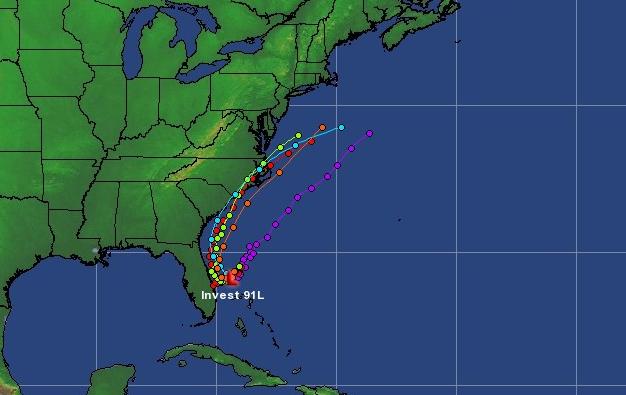
• An area of low pressure now forming off the southeast US coastline is likely to become a tropical system within the next 48 hours according to the National Hurricane Center. The interaction of this system with the aforementioned fronts could lead to an enhanced heavy rain threat.
• There is still some uncertainty with the track of this low pressure system. However, a majority of the data suggests an eventual northerly track to the Carolina coastline before curving northeast off the Mid-Atlantic coastline.
• Depending on the eventual track of this low, winds and tides may be of concern, especially Thursday and Friday.
• Rip currents will also be a major threat throughout most of the July 4th holiday weekend.
This is not Superstorm Sandy. No landfall is expected in New Jersey or Delaware. However…heavy rain, winds, tidal and freshwater flooding, rip currents, and heavy surf are possible as we head into a major holiday weekend. Stay tuned for the latest information at www.weather.gov/phi.