

The best location for a third Bay Bridge would be adjacent to the current spans, according to a state agency report. Two other options — one north of the existing bridges and one south — out of the five remaining alternatives also will undergo additional study.
The Maryland Transportation Authority selected the three alternatives based on traffic congestion, safety, dependable and reliable travel times, flexibility for maintenance and incident management, and financial viability.
The ongoing study also will include a no-build alternative.
Phase 1 of the Chesapeake Bay Crossing Study outlined 14 possible alternatives. Corridors 1-4 and 10-14 were eliminated from further consideration because those locations would not provide adequate traffic capacity to reduce congestion at the current crossing.

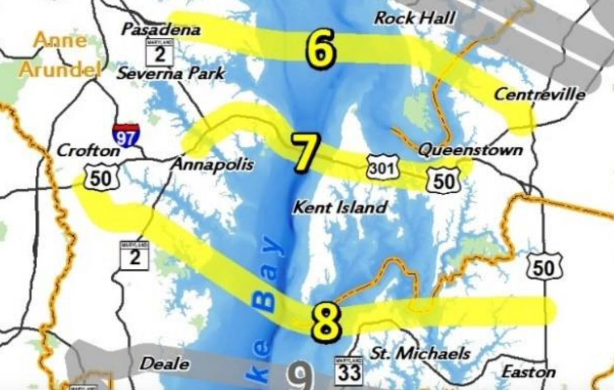
A study of potential sites for a new crossing of the Chesapeake Bay initially included 14 options. Corridors 6-8, highlighted in yellow, remain under consideration.
Phase 2 looked in more detail at corridors 5-9 and further reduced the alternatives to Corridors 6, 7, and 8.
Corridor 7 is where the existing Bay Bridge spans are located.
Corridor 6 would be north of the current bridges, with the western end located east of Pasadena in Anne Arundel County and the eastern side connecting near Rock Hall in Kent County before crossing the Chester River into Queen Anne’s County and connecting with Route 213 south of Centreville.
Corridor 8 would be south of the current bridges, with the western end located south of Annapolis. The bridge would pass south of Kent Island, connecting with Talbot County and ultimately to U.S. Route 50 north of Easton.
The detailed traffic analysis for the five remaining corridors showed “Corridor 5 would not provide an acceptable level of flexibility for incident diversion and would cause potentially major indirect effects on the Eastern Shore. Corridor 9 would also require substantial additional travel time for incident diversion and would result in unreasonably long duration of queues on summer weekends at the existing crossing (six hours with queues of one mile or greater on non-summer weekdays),” according to the report. And both Corridors 5 and 9 would do little to improve congestion at the current crossing based on traffic projections for 2040.
Cost and environmental impacts also are factors and Corridor 7, with the shortest overall crossing, would likely cost the least and “would likely result in fewer overall direct impacts.”
“While Corridors 6, 7, and 8 are all recommended to be carried forward for further evaluation, the screening results show that Corridor 7 has advantages over Corridors 6 and 8,” according to the report. “The advantages of Corridor 7 include better congestion relief at the existing Bay Bridge, more effective reduction of duration of unacceptable LOS (level of service), more effective backup reduction at the Bay Bridge, the best diversion route, and better compatibility with existing land-use patterns likely resulting in fewer indirect effects.”
Read the full report here:
BCS Alternatives Report
Rev Julia Hart says
Whatever is done will be inadequate. Time and history have proven that. Environmentalists will have a hoot of a time with any of it. And so will the citizens who will be directly impacted. So whomever is planning this time won’t do any better than the last “new bridge.” If they had double decked with 5 or 6 lanes on the last “new bridge” we would NOT be in this current situation. I’m sure there were dozens of reasons why that couldn’t be done. So what will be the reasons this time? And have studies over time shown which license plates prevailed besides MD? PA or DC or even VA? That has to say something, as far as north or south placement. So many factors to consider, especially the human factor.
I have pictures from my Mother of the old (the 1st) bridge being built. A couple of the pictures show her holding me as a toddler as we crossed on the Ferry. In those days not every household had a car. Now most households have at least two. Just to make a point on the increase of cars and traffic in my 70 years of life.
None of us knows what the future holds. But time and history have shown that humans plan and God laughs–as the saying goes.
The Rev Julia Hart
Elizabeth Fisher says
Thank you for bringing this back to our attention. COVID-19 has been a distraction, but this is important not to lose track of. Crossing 8 would have huge negative impacts on Talbot County residents. All interested residents need to watch closely, and give feedback where possible. It’s encouraging that site 7 is still considered the best bet if a 3rd span is to actually be built. Meanwhile, dramatically slowing new residential construction on the Eastern Shore would alleviate worsening of the current situation. I do like the earlier comment, too bad we can’t make ferries work again.
Matt LaMotte says
Sigh…
Ever since the 2nd, parallel span was completed, these plans resurface about every 10 years.
Too many “NIMBY’s” for this to happen anytime soon!