MENU

Sections

  • Home
  • About
    • Contact Us
    • Editors and Writers
    • Join our Mailing List
    • Letters to Editor Policy
    • Advertising & Underwriting
    • Code of Ethics
    • Privacy
    • Talbot Spy Terms of Use
  • Art and Design
  • Culture and Local Life
  • Public Affairs
    • Ecosystem
    • Education
    • Health
    • Senior Life
  • Community Opinion
  • Sign up for Free Subscription
  • Donate to the Talbot Spy
  • Cambridge Spy
  • Chestertown Spy

More

  • Support the Spy
  • About Spy Community Media
  • Advertising with the Spy
  • Subscribe
June 8, 2023

Talbot Spy

Nonpartisan Education-based News for Talbot County Community

  • Home
  • About
    • Contact Us
    • Editors and Writers
    • Join our Mailing List
    • Letters to Editor Policy
    • Advertising & Underwriting
    • Code of Ethics
    • Privacy
    • Talbot Spy Terms of Use
  • Art and Design
  • Culture and Local Life
  • Public Affairs
    • Ecosystem
    • Education
    • Health
    • Senior Life
  • Community Opinion
  • Sign up for Free Subscription
  • Donate to the Talbot Spy
  • Cambridge Spy
  • Chestertown Spy
News Maryland News

Marylanders Urge Transparency at Legislative Redistricting Advisory Commission Hearing

October 6, 2021 by Maryland Matters

Marylanders urged members of the General Assembly’s Legislative Redistricting Advisory Commission at a Tuesday hearing to make draft maps available for public comment before the panel’s last public hearing in November, arguing that the public should have a chance to weigh in before the General Assembly takes them up for a vote.

“It seems rather difficult for people to comment on the basis of a blank map,” Jacqueline Coolidge of the League of Women Voters told the panel at the online hearing.

Edward Johnson, co-leader of the Maryland Legislative Coalition, a progressive advocacy group, said that meaningful hearings can happen only when the commission presents draft maps.

Legislative leaders are tentatively planning a special session in early December to handle congressional redistricting, and Johnson said maps should be produced for public comment before then.

Morgan Drayton, policy and engagement manager for Common Cause Maryland, also urged the commission to produce draft maps before it concludes its public hearings in November. And she said the commission should consider starting its next statewide virtual public hearing at 6 p.m., rather than 3 p.m., to allow Maryland residents who work during the day to participate.

Nicole Y. Drew of Delta Sigma Theta, a public service-focused sorority that advocates for black communities, said the commission needs to undertake a “fair and transparent” process. She also urged members of the commission to ensure that people of color don’t have their votes diluted in the state’s next set of maps.

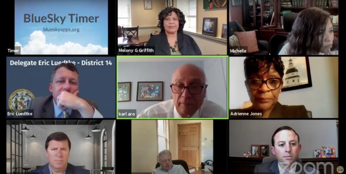
Commission Chair Karl Aro, a former director of the Department of Legislative Services, said the commission “will have draft maps for comment” but is gathering information.

Commission member Sen. Bryan W. Simonaire (R) noted the commission is set to conclude its public hearings on Nov. 18, and pressed Aro on when draft maps will be available for public comment.

Aro said he hopes the commission will produce draft maps by Nov. 15, and said the pandemic-related delay in Census redistricting data is to blame for the panel’s time constraints.

Aro said the public will also be able to comment when proposed district maps come up for committee hearings in the General Assembly’s special and regular sessions.

The Legislative Redistricting Advisory Commission’s next in-person meeting is set for Tuesday, Oct. 12 at 6 p.m. at Morgan State University in Baltimore.

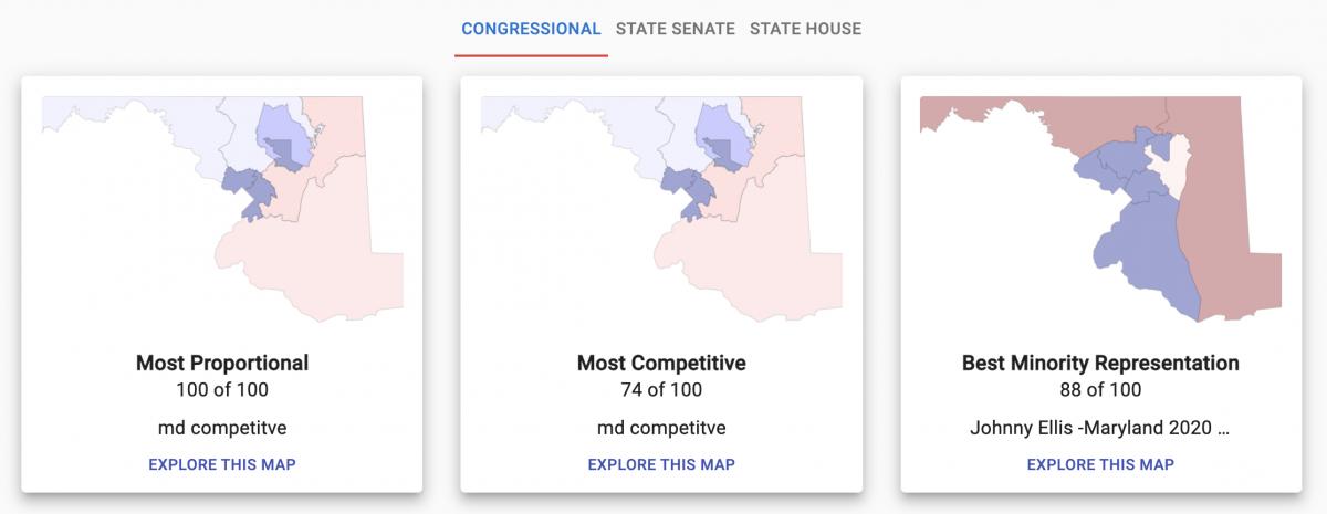
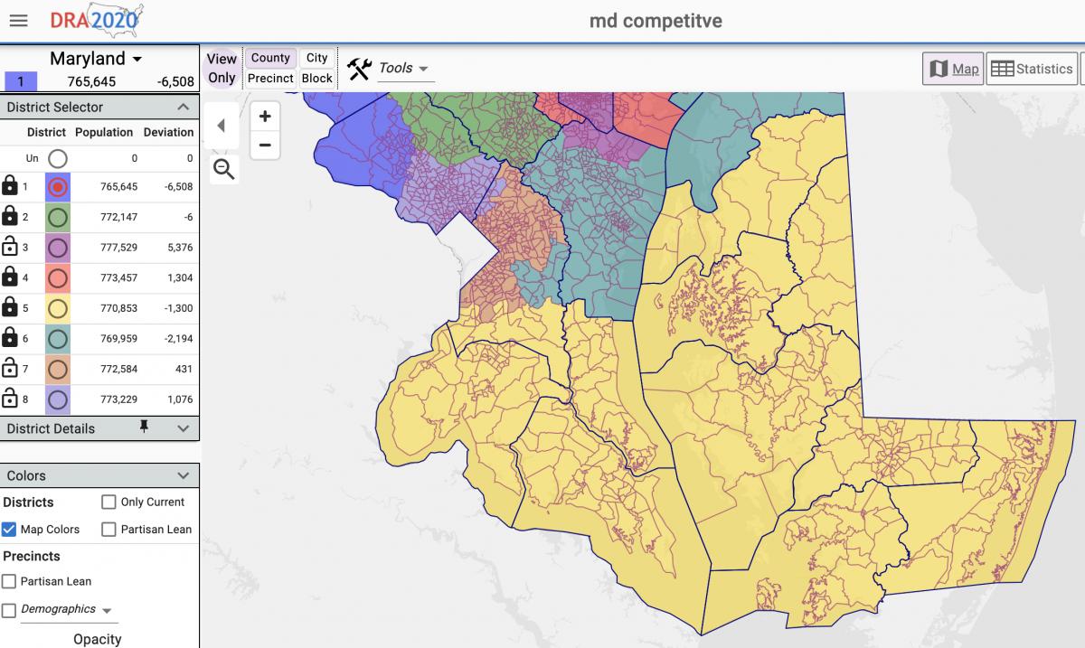
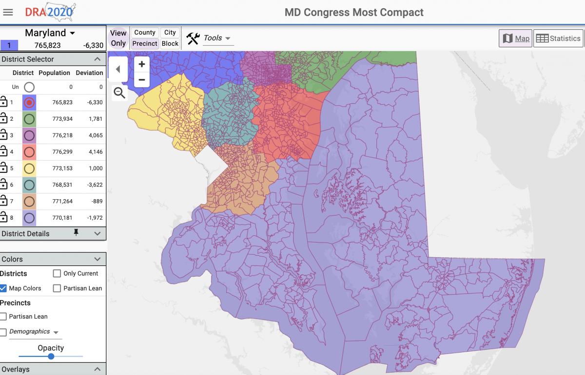
The Maryland Citizens Redistricting Commission, a separate panel created by Gov. Lawrence J. Hogan Jr. (R) to draw maps that he will propose to the General Assembly, has already drafted maps for state senate and congressional districts and is currently weighing single- vs. multi-member delegate districts. That panel is set to begin its final round of virtual public hearings Wednesday at 6 p.m.

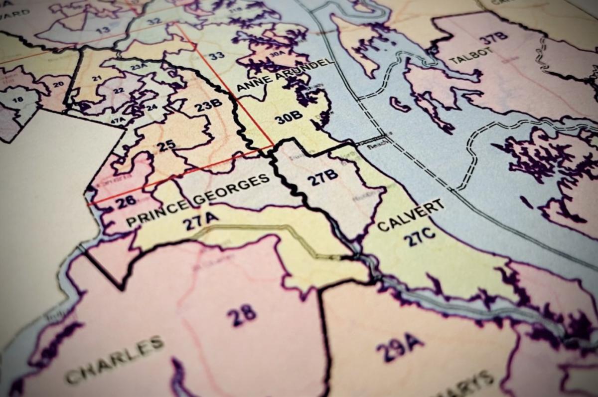
On Tuesday, the legislative commission also heard from Brandon Russell, a St. Mary’s County resident, who urged them to keep his county whole in congressional and state legislative maps. He noted that members of the Maryland Citizens Redistricting Commission included a portion of St. Mary’s County with Calvert County in their initial senate district maps, but that commission reversed course after backlash from county residents and made the county whole in a subsequent draft.

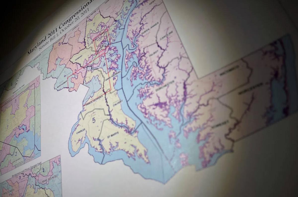
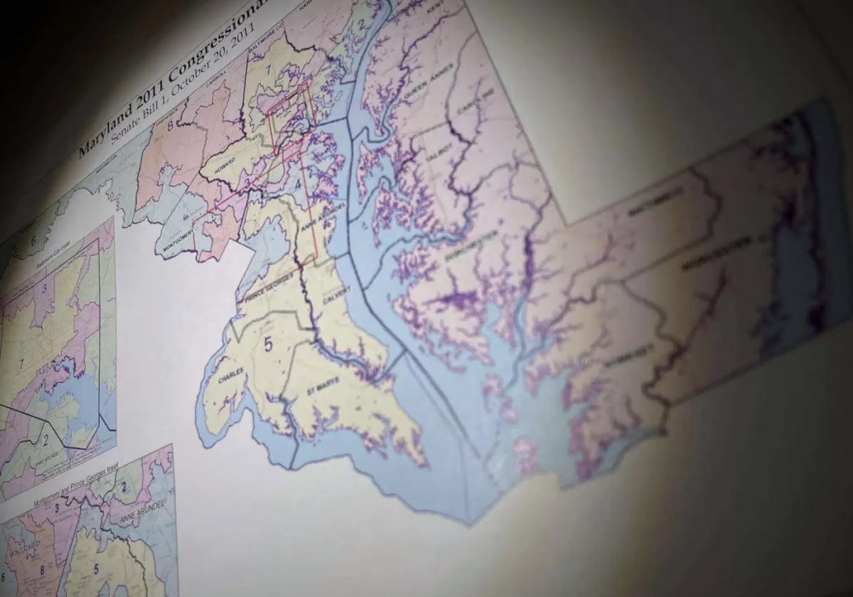
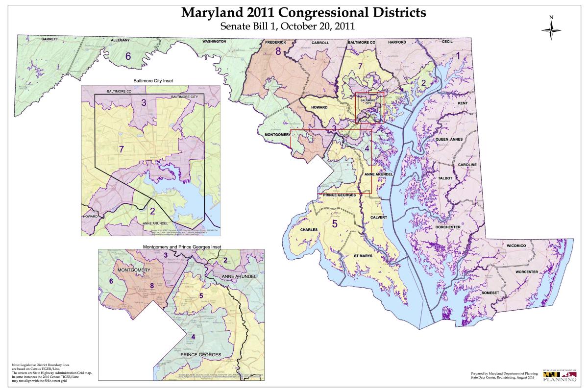
While both the Maryland Citizens Redistricting Commission and Legislative Redistricting Advisory Commission are tasked with conducting public hearings and drafting maps for congressional and state legislative districts, the General Assembly will have the final say over the state’s coming redistricting. Democrats hold a veto-proof majority in both the House of Delegates and the Senate.

By Bennett Leckrone

The Spy Newspapers may periodically employ the assistance of artificial intelligence (AI) to enhance the clarity and accuracy of our content.

Filed Under: Maryland News Tagged With: advisory commission, districts, general assembly, maps, Maryland, redistricting, transparency

Mid-Shore Saw Little Population Growth; QA’s County Added 2K Residents, Kent Lost 1K

September 8, 2021 by John Griep

Although Maryland’s population increased nearly 7% between 2010 and 2020, population growth on the Mid-Shore was virtually stagnant. Queen Anne’s County accounted for most of the growth in the last decade; Kent County’s population decline was the highest in the region.

Census population numbers are used to “determine the number of seats each state has in the U.S. House of Representatives and is also used to distribute hundreds of billions of dollars in federal funds to local communities,” according to the U.S. Census Bureau.

The numbers are also used to draw state legislative districts and county-level districts for county council or commission and board of education where those seats are elected by district.

While much of the focus is on the congressional and state legislative districts, the 2020 population figures may require some small adjustments for county-level seats that are elected from districts.

Queen Anne’s County, with 2,000 more residents, likely will require the most adjustments for its county commission and school board seats, depending on where the new residents are distributed. Kent County does not elect members from districts for county commission or school board and will not need to make any adjustments despite losing nearly 1,000 residents.

Mid-Shore public bodies with districts include:

Caroline County — board of education, three districts;

Dorchester County — county council, five districts; board of education, five districts;

Queen Anne’s County — county commissioners, four districts, one at-large; board of education, four districts, one at-large;

Talbot County — board of education, seven districts.

The biggest battles will occur with the congressional and state legislative district maps. Maryland’s current congressional map is considered one of the most gerrymandered in the nation. Gov. Martin O’Malley and Democratic lawmakers packed Democratic areas into a western Maryland district that had repeatedly elected a Republican to Congress. The mapping process following the 201o Census also put more Republicans into the First District, which encompasses the Eastern Shore.

As a result, Maryland’s congressional representation went from six Democrats and two Republicans to seven Democrats and one Republican (the First District’s Andy Harris).

Two redistricting commissions — one appointed by Gov. Larry Hogan and another by Maryland legislative leaders — are already at work on the maps for the congressional and legislative district maps.

The state planning department offers adjusted redistricting data on its website, which also includes a link to a mapping web portal through which anyone may submit proposed redistricting maps for review by the Maryland Citizens Redistricting Commission appointed by Hogan.

Outside groups also have offered maps, with several available to view at Dave’s Redistricting, “a free web app to create, view, analyze and share redistricting maps for all 50 states and the District of Columbia, according to the site.

The website offers five notable maps — most proportional, most competitive, best minority representation, most compact, and least splitting — for congressional, state senate, and state house redistricting plans.

At presstime, the notable congressional maps for proportionality, competitiveness, and compactness would split the Eastern Shore into two districts. The First Congressional District currently includes the entire Eastern Shore from Cecil to Worcester county and portions of Harford, Baltimore, and Carroll counties.

The current most proportional and most competitive congressional map would create a district that includes Queen Anne’s to Worcester county on the Eastern Shore, the southern Maryland counties of Calvert, Charles, and St. Mary’s, and a portion of Prince George’s County. That district is seen in yellow below.

The most proportional and most competitive Maryland congressional district maps published thus far would include seven Eastern Shore counties, three southern Maryland counties, and a portion of Prince George’s County. Screenshot from Dave’s Redistricting.

The most compact congressional map has a district that includes Kent to Worcester county, the three southern Maryland counties, and portions of Prince George’s and Anne Arundel counties. That district is seen in light purple below.

The most compact Maryland congressional district maps published thus far would include eight Eastern Shore counties, three southern Maryland counties, and portions of Prince George’s and Anne Arundel counties. Screenshot from Dave’s Redistricting.

The Spy Newspapers may periodically employ the assistance of artificial intelligence (AI) to enhance the clarity and accuracy of our content.

Filed Under: News Homepage Tagged With: census, congressional, county, districts, legislative, maps, Maryland, mid-shore, population, redistricting, school board

It’s Map Drawing Time. Citizens Redistricting Commission Opens Public Submissions

September 3, 2021 by Maryland Matters

Marylanders can now submit their own proposals for redistricting to the Maryland Citizens Redistricting Commission, state officials announced Thursday.

The Maryland Department of Planning’s new submission portal allows users to map their proposals for congressional and state legislative districts, and includes instructions on how to draw districts.

Members of the Maryland Citizens Redistricting Commission will review maps that are received by noon on Sept. 24, according to the planning department. More submissions will be accepted when that panel begins its third round of hearings in October.

The map submission portal uses redistricting data which counts incarcerated Marylanders as residents of their last known address, as required by Maryland law, according to the release.

The nine-member commission — which includes three Democrats, three Republicans and three unaffiliated voters — is set to start a new round of public hearings on Sept. 9. That hearing will be virtual.

The commission worked with Stanford Law School professor Nathaniel Persily to hash out some rough criteria for maps on Wednesday. Although the commission won’t make its redistricting proposal for some time and will consider citizens’ proposals, members said they hope to have some early drafts ready for public comment by next week.

Commission members also mulled whether to keep the Eastern Shore whole or cross the Chesapeake Bay to create a district consisting of part of Southern Maryland and the Lower Shore. Commission Member Kimberly Rose Cummings (R), a Dorchester County resident, noted that some Lower Shore residents told panelists, during an initial round of public hearings, that they have more in common with Southern Maryland residents than with residents of north and central Maryland.

There is historical precedent for crossing the Chesapeake Bay in a congressional district, as the state’s 1st Congressional District once included portions of Southern Maryland as well as the entire Eastern Shore from the early 1970s to the early 1990s. The 1st District currently includes all of Maryland’s Eastern Shore and portions of Baltimore, Harford and Carroll countries.

Commission Co-chair Alexander Williams Jr. (D), a Prince George’s County resident and retired federal judge, said that rapidly developing Charles County has more in common with parts of Prince George’s County than with other parts of Southern Maryland. Commission members chose to leave both options on the table for public comment and map submissions.

As for drawing a district in Western Maryland, commission Co-chair Walter Olson (R) said the panel should look to include Carroll County with Frederick, Garrett and Allegany counties. Olson and Williams served on an emergency commission to redraw the state’s 6th Congressional District before the Supreme Court reversed a 2018 order to redraw the district. Olson said that, during the emergency commission’s run, Carroll County residents “overwhelmingly” asked to be included in a Western Maryland district.

Whether the Western Maryland district would draw from portions of northern Montgomery or Howard counties remains an open question for commission members.

None of the commission’s initial criteria are set in stone, rather they are meant to be a baseline for public comment during upcoming public hearings.

Gov. Lawrence J. Hogan Jr. (R) created the Maryland Citizens Redistricting Commission via executive order to draw congressional and legislative maps that he will propose to the General Assembly. Democrats hold a veto-proof majority in both the House of Delegates and the Senate, and lawmakers will have the final say over the state’s next set of maps.

Senate President Bill Ferguson (D-Baltimore City) and House Speaker Adrienne A. Jones (D-Baltimore County) created their own bipartisan redistricting commission, the Legislative Redistricting Advisory Commission, to draw congressional and legislative maps. The legislative commission held its first meeting this week and is set to kick off a statewide round of public hearings on Sept. 20 with a hearing focused on Prince George’s County.

By Bennett Leckrone

The Spy Newspapers may periodically employ the assistance of artificial intelligence (AI) to enhance the clarity and accuracy of our content.

Filed Under: Maryland News Tagged With: census, commission, congressional, districts, legislative, maps, Maryland, redistricting

Analysis: Census Data and the Political Reordering to Come in Md.

August 16, 2021 by Maryland Matters

Baltimore City leaders knew they were coming.

And yet, the newest population numbers from the U.S. Census, delivered Thursday on the hottest day of the year, hit them like a torrent of cold water in the face.

Baltimore’s dramatic 5.7% population loss over the past 10 years means the city is sure to face a corresponding loss of political clout in the decade ahead — no matter how many allies it has in the highest echelons of power in Annapolis.

That’s one of many political threads that will be pulled over the next several months, as state politicians and policymakers seek to use the Census data as part of the recipe for congressional and legislative district maps that will be in place until the elections of 2032.

Baltimore wasn’t the only Maryland jurisdiction to see significant population losses — far from it. But the latest numbers did produce a significant degree of handwringing in the city.

Donald C. Fry, president and CEO of the business group the Greater Baltimore Committee, called it “unacceptable for a city with the many positive attributes Baltimore has, from its affordability, diversity, strong neighborhoods, historical and cultural attractions to world class healthcare and universities, to lose residents.”

Baltimore Mayor Brandon M. Scott (D) scrambled to put the dreary numbers in historical context and asserted that city leaders are putting policies in place to stanch the bleeding and slowly build back the city’s population.

“Today’s population figures are the culmination of more than 70 years of population decline, showing why we must pivot from the status quo towards inclusive economic policies that improve the lives of our legacy residents, while attracting new residents,” Scott said Thursday. “Understanding that much of Baltimore’s 21st century population loss has been driven by an exodus of African American households, my administration will be focused on equitable economic development. We can no longer leave any corner of our city behind.”

Census figures help determine how much federal aid is distributed to states and local jurisdictions, but they are also key weapons in the raw redistricting political battles that will follow.

Overlaying Maryland’s current congressional and legislative district maps with the map of of the latest county-by-county population trends is an interesting exercise.

Even the most gerrymandered political maps must start at the corners of the state — far Western Maryland and the Lower Eastern Shore. And at both poles of the state, the population, with the exception of Wicomico County on the Shore, has declined over the past decade. That’s part of a national trend that saw rural population drop sharply while it increased in urban and suburban areas — and will have implications for what congressional and legislative boundaries in Maryland look like.

From the minute he took office, Gov. Lawrence J. Hogan Jr. (R) has sought to inject himself in the redistricting process — or at least take the power away from the Democratic supermajorities in the General Assembly and, by extension, the most senior Democrats in the state’s congressional delegation. But the fact remains that legislative leaders, working in tandem with U.S. House Majority Leader Steny H. Hoyer (D-Md.), will have the most say.

For State House Democrats, knowing that Republican legislatures will attempt to help the GOP seize control of the U.S. House of Representatives by muscling through baldly gerrymandered maps, there will be temptations to create an 8-0 Democratic congressional map in Maryland (the state delegation currently has seven Democrats and one Republican). But the Census figures show that population trends in certain red states weren’t as stark as they could have been — meaning Republicans won’t have quite as much power to bludgeon Democrats in those places as they might have expected.

“Early read: based on the strong urban and weaker rural numbers I’m seeing, this is a much more favorable Census count than minority advocacy groups/Dems had feared,” Dave Wasserman, the House analyst for the nonpartisan Cook Political Report tweeted Thursday.

As a result, Maryland Democratic strategists believe, party leaders are more likely to try to produce a 7-1 Democratic congressional map again — albeit one that is cleaner, with fewer tortured contours, and that is less susceptible to lawsuit than the post-2010 Census map.

Baltimore City currently has three congressional districts cutting through its borders. Anne Arundel County has four. Howard County has three. Baltimore County has four. The result is messy, nonsensical districts in the central part of the state. That may change.

With population losses on the Eastern Shore, the 1st Congressional District, held by the state’s lone Republican member of Congress, Rep. Andrew P. Harris, will probably need to gain more territory on the western side of the Chesapeake Bay. Where those precincts are added may determine how competitive a re-election race Harris will face in 2022 — most likely against former state Del. Heather R. Mizeur (D).

Maryland mapmakers actually have more flexibility when it comes to drawing legislative districts — where population variations of as much as 10% are permissible (each congressional district must contain the exact same population, to the extent possible). Even so, Baltimore City, which has steadily lost representation over the past few decades, is likely to lose more seats.

It’s already accepted wisdom in Annapolis that the 44th District, which currently contains a one-member House subdistrict in Baltimore City and two House seats in Baltimore County, will push out into the county exclusively — meaning the legislative tenure of Roxane Prettyman (D), who has been recommended by the Baltimore City Democratic Central Committee to fill a vacancy in District 44A, could be short-lived.

Another Baltimore City legislative district that has seen modest population growth, District 46, may have to lose some city precincts to make whole other city districts — and could extend south toward Glen Burnie or even BWI Thurgood Marshall Airport.

Howard County’s population growth means it may no longer have to share one legislative district with Baltimore County. Frederick County’s population growth means it may not have to share a legislative district with Carroll County. Southern Maryland’s representation in Annapolis is also likely to grow — though Democrats undoubtedly will try to maximize their advantage in fast-growing Charles County, which, according to the latest Census figures, is now over 50% Black.

And population losses in Garrett and Allegany counties mean the 1st legislative district will necessarily have to push farther east into Washington County.

The Maryland Department of Planning will now take the Census figures and spend the next few weeks adjusting them to account for the state’s incarcerated population. Under state law, incarcerated individuals are countered as residents of the jurisdictions where they previously lived, rather than the jurisdiction of the prisons where they are serving their sentences. This could help limit Baltimore City’s population loss to a small degree.

Hogan and legislative leaders are relying on the work of dueling redistricting commissions to help guide them on the maps they will propose in an upcoming special session of the General Assembly to finalize a congressional map, and during the regular 2022 session when legislative lines must be adopted. Even though Democrats have the upper hand, Hogan was already attempting to grab the moral high ground on Thursday.

“All across our state, Marylanders are demanding an end to partisan gerrymandering from partisan politicians in the legislature and supporting the work of the independent and nonpartisan Maryland Citizens Redistricting Commission,” he said on Twitter.

By Josh Kurtz

The Spy Newspapers may periodically employ the assistance of artificial intelligence (AI) to enhance the clarity and accuracy of our content.

Filed Under: Maryland News Tagged With: 2020, census, congressional, districts, gerrymandering, legislative, Maryland, redistricting

Hearing Tonight on Easton Draft Zoning Code

July 6, 2021 by Spy Desk

The Easton Planning and Zoning Commission recently completed a comprehensive examination and revision to the town’s zoning code.

The Easton Town Council will have a public hearing on the draft zoning code at 5:35 p.m. Tuesday, July 6, in the council meeting room at 14 S. Harrison St. in Easton.

The planning commission has highlighted the following as “the most significant proposed changes” in the proposed zoning code:

1. A revised Planned Unit Development (PUD) Chapter. Currently there is one process and set of standards/criteria for any proposed PUD, regardless of type or context of the development proposal. The new DRAFT Code proposes to distinguish three types of PUDs, with standards unique to each development scenario. The three PUD subtypes are PUD – General, PUD – Infill, and PUD – Redevelopment. The intent of this change is to move away from a “one size fits all” PUD for any development type to three slightly different types corresponding to specific development scenarios, with corresponding review processes and development standards believed to be more appropriate to each scenario. A primary goal of this change is to facilitate more infill and redevelopment projects.

2. A revised Sign Regulations Chapter. In addition to a general reformatting of this chapter, provisions for temporary signs are extensively and significantly revised to comply with a recent Supreme Court ruling and window signs are proposed to be regulated for the first time.

3. The Critical Area Chapter is revised as required by a mandated update of our Critical Area Program. The chapter follows the latest State model for this chapter of our Code with a few local modifications carried forward from the existing Ordinance.

4. A number of measures are proposed to promote the general theme of increasing housing options and opportunities, especially in the general area “in and around Downtown” and with a particular focus on affordable housing options. Such measures include increased density in some contexts/locations, the identification of new housing types (e.g., so-called Middle Housing types including triplexes, fourplexes, cottage courts, mansion apartments, and courtyard buildings), and a simpler review process for certain housing types in certain locations.

5. The rezoning of parcels currently zoned CG (General Commercial) located in relatively close proximity to Downtown from CG to CBD (Central Business District) in recognition that such parcels are more like Downtown in their development characteristics than they are the commercial areas along Route 50, Elliott Road, or Marlboro Avenue, which are also zoned CG.

6. The elimination of the I-1 and I-2 Zoning Districts and the rezoning of any properties zoned as such to either BC (Business Commercial) or I (Industrial). This was done in recognition of the fact that many of the Town’s industrially-zoned areas have transitioned to more of an office/service/light industrial area as opposed to traditional industrial uses. The BC Zoning District was created in part to reflect this land use. The I Zoning District is proposed to reserve lands for the more traditional industrial uses.

 7. A number of proposed changes for Port Street between the Parkway and Washington Street focused on infill and redevelopment consistent with the Port Street Small Area Plan, with the intent to insure that this corridor serves as an important link between the Waterfront and Downtown.

The proposed chapters of the code may be viewed at the links below:

  1. 2021-04-13 Proposed Zoning Map DRAFT
  2. Table of Contents
  3. ARTICLE I – GENERAL
  4. ARTICLE II – PERMITTED USES
  5. ARTICLE III – ZONING DISTRICT REGULATIONS
  6. ARTICLE IV – Critical Area_Model_Town_Ordinance
  7. ARTICLE IX – SITE PLAN REVIEW
  8. ARTICLE V – Planned Redevelopment Overlay
  9. ARTICLE VI – Historic District
  10. ARTICLE VII – PLANNED UNIT DEVELOPMENT
  11. ARTICLE VIII – PLANNED HEALTHCARE DISTRICT
  12. ARTICLE X – SUPPLEMENTAL ZONING REGULATIONS
  13. ARTICLE XI – SIGNS
  14. ARTICLE XII – NON-CONFORMING LOTS, USES AND STRUCTURES
  15. ARTICLE XIII – Administration and Enforcement
  16. ARTICLE XIV – AMENDMENTS
  17. ARTICLE XV – DEVELOPMENT RIGHTS AND RESPONSIBILITIES AGREEMENTS

The Spy Newspapers may periodically employ the assistance of artificial intelligence (AI) to enhance the clarity and accuracy of our content.

Filed Under: News Homepage Tagged With: critical area, districts, Easton, planning, public hearing, PUD, rezoning, signs, town council, zoning

Redistricting Commission Urged To Adopt Single-Member Delegate Districts At First Public Hearing

June 10, 2021 by Maryland Matters

Eastern Shore residents urged the Maryland Citizens Redistricting Commission to adopt single-member legislative districts at a virtual hearing Wednesday evening, with some charging that the state’s current hybrid model is unfair for voters.

The executive order from Gov Lawrence J. Hogan Jr. (R) that created the commission requires that, to the extent practicable, commissioners include single-member delegate districts in the proposed maps. The state’s current House of Delegates districts vary between single-member and multi-member districts, a system that some Eastern Shore residents oppose.

Bill Satterfield, a Wicomico County resident, urged members of the commission to adopt single-member districts. He said the state’s current system means that some voters have greater power in the legislature compared to others.

“Everybody should have one vote for one person,” Satterfield said.

Sen. Mary Beth Carozza (R-Lower Shore) likewise urged members of the commission to move toward single-member districts. Carozza herself was elected in a single member House district, District 38C in Wicomico County, before being elected to the Senate.

“I can speak to the effectiveness of serving my constituents in that capacity,” Carozza said.

Muir Boda, a Salisbury City Council member, said multi-member districts often confuse residents over who to contact on legislative issues.

Carozza also urged commissioners to keep the Eastern Shore whole in the redistricting process. The entire region is currently included in Maryland’s 1st Congressional District, which is home to the lone Republican member of Maryland’s congressional delegation, Rep. Andrew P. Harris.

Boda urged commissioners to create “contiguous” districts that keep communities together. He noted the vast difference between Ocean City on the Lower Shore and Taneytown in Carroll County, and said the commission may want to consider creating a district that would include parts of Southern Maryland along with the Eastern Shore.

Community outreach was another prominent topic at the meeting, with some residents urging commission members to better publicize future rounds of public hearings. Demba Ndiaye said he received notice of the meeting just days before it was going to take place.

“This commission, at this time, needs to focus more on outreach and communication to get more people involved in this process,” Ndiaye said.

Moonyene Jackson-Amis, a Talbot County resident, urged the commission to do more intensive outreach to communities on the topic of single-member and multi-member districts. She said each community will be impacted differently by how districts are drawn.

“I don’t know really what the impact would actually be for the population that I’m most concerned about,” Jackson-Amis said. “We need more representation from the African American community.”

Kathleen Hetherington (I), the president of Howard Community College and one of the commission’s co-chairs, said Wednesday that more public hearings will take place as the commission draws up maps.

The multi-partisan commission is tasked with drawing up congressional and state legislative maps for Hogan to submit to the General Assembly, and is currently holding a round of public hearings before the release of 2020 Census redistricting data. The maps that Hogan submits will ultimately be subject to approval and revision by the General Assembly.

By Bennett Leckrone

The Spy Newspapers may periodically employ the assistance of artificial intelligence (AI) to enhance the clarity and accuracy of our content.

Filed Under: Maryland News Tagged With: commission, districts, Eastern Shore, Gov. Larry Hogan, Maryland, redistricting, single member

Maryland Faces ‘Extreme’ Threat of Gerrymandering, New Report Says

April 6, 2021 by Maryland Matters

Maryland is under “extreme” risk for gerrymandering when lawmakers draw up new election districts, according to a new report from an anti-corruption watchdog group.

The Gerrymandering Threat Index from the nonprofit group RepresentUs lists Maryland, alongside 26 other states, in the highest risk category for gerrymandering. States are listed under the group’s “extreme” risk category for giving “politicians complete control over an often-secretive, poorly-protected redistricting process.”

RepresentUs considered five questions when determining a state’s threat level for gerrymandering:

  • Can politicians control how election maps are drawn?
  • Can election maps be drawn in secret?
  • Can election maps be rigged for partisan gain?
  • Are the legal standards weak?
  • And, are rigged election maps hard to challenge in court?

The report cites Maryland’s Democratic supermajority as a flag for potential gerrymandering, since the state relies on the legislature to approve maps. Maryland’s governor initially crafts congressional and legislative maps that are presented to the General Assembly. Lawmakers can pass a resolution (not subject to veto) changing the legislative districts. The Maryland Constitution sets some requirements for legislative districts, including that they must be compact and give “due regard” to jurisdictional boundaries.

Congressional district maps aren’t subject to the same restrictions under the Maryland Constitution. The governor can veto the legislature’s proposed congressional district map —but lawmakers could override a veto from Gov. Lawrence J. Hogan Jr. (R), as they’ve done on several key pieces of legislation during the 2021 session and throughout his tenure.

Hogan has repeatedly attempted to create a bipartisan redistricting process since he took office, but his efforts have failed to pass the General Assembly. In January, he signed an executive order creating a bipartisan commission to make recommendations for the congressional and legislative maps that he will submit to the legislature ahead of the 2022 election.

Attempts to challenge the state’s congressional districts in court have also failed, with the U.S. Supreme Court declaring in 2019 that federal judges shouldn’t be the ones to settle disputes on gerrymandering.

That high court ruling came after a panel of federal judges ordered the state’s 6th Congressional District redrawn, arguing that the district had been unconstitutionally drawn to benefit Democrats.

Rep. John P. Sarbanes’ (D-Md.) omnibus election reform proposal, the For the People Act, would include a congressional redistricting overhaul and ban partisan gerrymandering. The sweeping reforms would also require states to use bipartisan, independent commissions to draw district lines.

The RepresentUs report lists the For the People Act as a “remarkable opportunity” to end federal gerrymandering.

“Ultimately, a system-wide crisis calls for a system-wide solution,” the report reads.

In all, the Gerrymandering Threat Index lists 35 states as having a high or extreme risk for partisan gerrymandering in the next round of redistricting. Two of Maryland’s neighboring states, Delaware and West Virginia, are also listed as having an “extreme” risk for gerrymandering. Pennsylvania is given a “moderate” rating, and Virginia a “low” rating.

Virginia voters last November approved a nonpartisan redistricting process.

By Bennett Leckrone

The Spy Newspapers may periodically employ the assistance of artificial intelligence (AI) to enhance the clarity and accuracy of our content.

Filed Under: Maryland News Tagged With: Congress, districts, gerrymandering, maps, Maryland, redistricting, report, risk, state legislature, supermajority

Md. Lawmakers Will Map Congressional Districts Based on 2020 Census

January 12, 2021 by Spy Desk

Maryland lawmakers later this year will draw new maps for the state’s congressional districts based on the latest population statistics from the 2020 Census.

The U.S. Constitution requires the census to be conducted every 10 years. The population numbers are then used by states to draw new congressional districts, which typically is completed in time for the congressional election two years after the census.

Following the decennial census, federal law requires states to be notified by Jan. 25 by the clerk of the U.S. House of Representatives on the number of congressional seats that state will have for the next 10 years.

That notification will be delayed this year, however, as the U.S. Census Bureau continues processing and tabulating the population numbers.

According to The Washington Post, the census bureau currently believes it will finalize state population numbers by March 6, more than two months after the Dec. 31 deadline.

The deadline was missed as a result of delays caused by the coronavirus pandemic and changes made by the administration of President Donald Trump, which is being sued over some of its decisions concerning the census.

Although the count continues, population estimates suggest Maryland will retain its eight seats in the U.S. House of Representatives.

Once the state is told how many seats it will have, Maryland lawmakers will draw new boundaries for those congressional districts. After the congressional map is approved by the Maryland General Assembly, it is subject to veto by Gov. Larry Hogan.


The Spy Newspapers may periodically employ the assistance of artificial intelligence (AI) to enhance the clarity and accuracy of our content.

Filed Under: Maryland News Tagged With: apportionment, census, Congress, districts, population, redistricting

« Previous Page

Copyright © 2023

Affiliated News

  • The Chestertown Spy
  • The Talbot Spy

Sections

  • Arts
  • Culture
  • Ecosystem
  • Education
  • Mid-Shore Health
  • Culture and Local Life
  • Shore Recovery
  • Spy Senior Nation

Spy Community Media

  • Subscribe
  • Contact Us
  • Advertising & Underwriting

Copyright © 2023 · Spy Community Media Child Theme on Genesis Framework · WordPress · Log in