

It is still early in the growing season, but scientists’ hopes are high that this year will produce a bumper crop of underwater meadows in the Chesapeake Bay.
After last year’s aerial survey documented a record 91,631 acres of submerged grasses spread over the Bay bottom, many think a new record for one of the estuary’s most critical habitats is likely, given early reports this spring of surprisingly clear water in parts of the Bay.
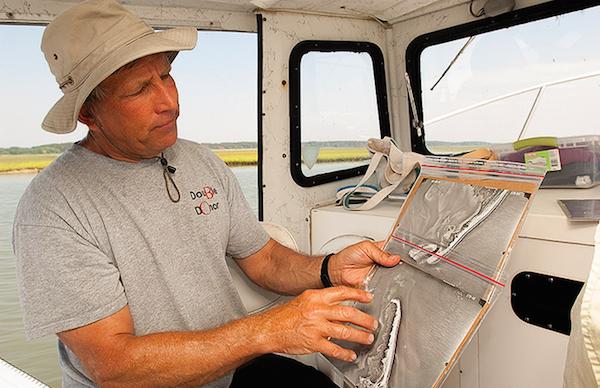
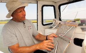
VIMS researcher Bob Orth goes over a map where he and his team will be ground-truthing a grass bed. (Dave Harp)
But Bob Orth is not so sure.
“It’s been one weird spring,” says Orth, a researcher with the Virginia Institute of Marine Science who oversees the aerial survey.
Partially completed aerial surveys for parts of the Eastern Shore, where many of the clear water reports have originated, are indeed showing further expansions. On the Western Shore, though, beds seem to be retreating in places.
Orth has tracked the rise and fall of grass beds for three decades. During that time, he’s learned that grass abundance can vary wildly from place to place, and from year to year, for a host of reasons.
But Orth is worried that this year’s tally could be the last. He has struggled in recent years to keep the survey going. This year, he’s $100,000 short of the $516,000 needed to complete the work.
The shortfall has arisen partly because of rising costs, but also because state and federal funding has dwindled over the years as agency budgets have tightened. More than a dozen agencies have funded the survey at one time or another, but just four do so now. The lion’s share comes from the U.S. Environmental Protection Agency, which has chipped in increasing amounts in recent years to keep the survey going.
The potential loss of the survey has alarmed scientists. Bay grasses are an essential part of the ecosystem; they filter sediment, add oxygen to the water and provide habitat for blue crabs, fish, waterfowl and a host of other species. Grasses need good water quality — especially clarity, so sunlight can reach them and enable them to grow. The annual survey results are one of the most anticipated indicators of how the Bay is doing.
“I don’t want to be over-dramatic, but if I had to pick one piece of data, what would I want for the Bay?” asks Bill Dennison, vice president for science applications with the University of Maryland Center for Environmental Science. “I would pick seagrasses.”
The annual survey provides one of the most crucial sets of information that he draws upon in producing his institution’s annual report card on Bay health. Beyond that, underwater grasses — unlike measures of dissolved oxygen or water clarity — represent an actual biological response to Bay conditions.
“It is more relevant, more widespread, and tells me more in an integrated sense how things are going,” Dennison says.
What’s more, restoring the grasses is an integral part of the legally binding Bay cleanup effort. State water-quality standards call for making the water clear enough to allow underwater grasses to grow on 185,000 acres of the bottom, with the distribution based on its historic abundance.
Without the survey, scientists say, it might be impossible to know if those goals are reached, thereby allowing the Chesapeake to be removed from its “pollution diet” — or at least the portion related to clear water.
“It’s one of those things that has been available for so long, everybody relies on it,” says Brooke Landry, a biologist with the Maryland Department of Natural Resources and chair of the Bay Program’s submerged aquatic vegetation workgroup. “It is just kind of institutional. I can’t imagine moving forward with Bay restoration without it.”
Landry says her own agency, which helps fund the survey but had decreased its contributions in recent years, is examining whether it can boost support again. The two other remaining funders include the National Oceanic and Atmospheric Administration’s Coastal Zone Management Program for Virginia and the Virginia Department of Environmental Quality.
Getting a Baywide handle on underwater grass beds became a priority in 1983, after the EPA released the results of a multiyear study of the estuary’s woes that cited seagrass loss as one of its top problems.
The annual survey began the next year, with VIMS mapping Virginia and an EPA contractor mapping Maryland. It counted 38,224 acres, the lowest amount on record.
Orth’s team at VIMS took over the whole operation three years later, and has conducted it every year since except 1988, when there was no funding.
It’s a job that starts in mid-May in the Lower Bay, where grass beds show up first, and continues north through the summer, typically wrapping up in September or October.
The process is drawn out because the window of opportunity to get usable photos of grass beds is small, requiring low wind, minimal clouds, low tides, clear water and a low angle of the sun striking the water — all at the same time.
“The very first, most important step to this entire program, has always been flying with the right conditions,” Orth says. “We could go an entire month in the summertime without one good day.”
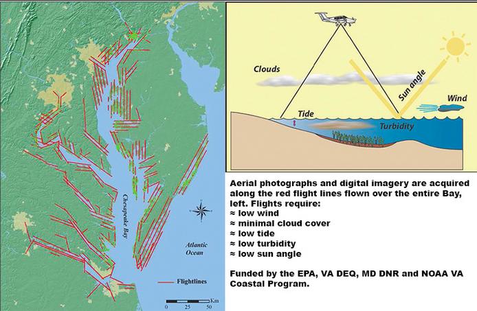
The window for getting the right mix of conditions in a given day is small: typically within 90 minutes of a low tide in the early morning. The light and tide conditions might be right in late afternoon, but it’s usually too hazy then, especially in summer.
“It’s a hair-pulling operation,” Orth says. “You have to take advantage of every open window.”
When the weather forecast predicts favorable conditions for flying the next day, Orth and the crew from Air Photographics, the West Virginia aviation firm that does the actual photography, begin talking early in the afternoon before. They touch base after each forecast update into the early morning hours to make sure conditions haven’t changed before making a final call on whether the flight is a “go.”
Some areas surveyed present unique problems. To fly near Aberdeen Proving Grounds in Maryland, the Army requires that someone from the installation be on the plane. The military also removes images of its land before the photos go to VIMS for mapping.
“We’ve got to call to make sure they’re not shooting artillery up in the air, which happens during the week,” Orth says. “A lot of times we can only fly Aberdeen Proving Grounds on the weekend.”
The tidal Potomac River near the District of Columbia also presents challenges because of security issues associated with the nation’s Capital, and an armed police officer has to be on board during those flights.
Despite the funding crunch and logistical challenges, right now there are no plausible substitutes for the flights, Orth says. Satellites pass too infrequently to reliably hit all of the right conditions for photography, and they encounter much more interference from the atmosphere.
The biggest expense isn’t the flights, but the staff and high-powered computers needed to fit the mosaic of 2,500 overlapping photos together, and determine which patches of light and dark are grass beds, and which are sandy bottom, floating macro-algae or something else.
Grasses may look different, depending on how far underwater they are and whether they are in fresh or saltwater. “It’s like being an artist,” Orth says. “You develop a sense for what’s grass and what’s not grass.”
Protocols developed over the years guide what’s mapped, and help the 4.5-member interpretation team estimate the density of each bed. When there’s a question, Orth — who originally did all of the interpretation himself — is called in to make the final determination. He also gives the final sign-off on all maps.
A network of contacts, from biologists to riverkeepers, provides information about potential new areas to check. It also helps verify beds in areas where questions remain after examining the photos.
From 13,500 feet, an amazingly sharp set of images emerges. Scars left by the propellers of boats that ventured into dense beds are clearly visible.
The images also provide insights into how beds persist and expand. On one photo, Orth pointed out a plume of clear water flowing at ebb tide from a large grass bed into murky water. In future years, he says, that swath of clear water will likely prove to be an avenue for the grass bed to expand.
“You’ve got large amounts of water that’s filtered by this bed,” he says. “You can see how clear the water is that comes out of these grass beds.”
Over the years, the survey has shown wide fluctuations in the grass beds’ extent. They typically decline after severe storms and in years with high runoff, when more water-clouding nutrients and sediment are flushed into the Bay. In drier years, they often rebound.
But the full story of the grasses in any given year isn’t complete with the calculation of the total Baywide acreage. It plays out in the smaller, more regional and local changes that the survey has helped to detail.
In general, grasses in freshwater areas have been rebounding as water quality has improved. But in mid-Bay waters dominated by widgeon grass, the vegetation has waxed and waned based upon annual conditions. And in the high-salinity waters of the lower Bay, the eelgrass prevalent there has gradually declined.
Eelgrass prefers cool water temperatures and the survey helped to document the extent to which it died back during heat waves in 2005 and 2010 — events from which those beds still have not fully recovered.
Survey results have also shown how grass beds dramatically rebounded in the upper tidal Patuxent River after wastewater treatment plants were upgraded in the 1990s, and how the Susquehanna Flats took a big hit but survived the devastating flood of muddy water during Tropical Storm Lee in 2011. Just last year, the survey documented a surge of new grass in many Upper Bay areas, such as the Elk and Bohemia rivers.
Over the years, biologists have used information from the survey in scores of scientific papers that parse why grasses come and go in various places.
Scientists aren’t the only ones that use the imagery, though. The biggest users have turned out to be federal and state regulatory agencies that need to know whether various projects, such as dredging, shoreline alterations or proposed aquaculture sites would hurt grass beds.
Without the survey, someone would have to visit the site in person. But if it was the wrong season or the wrong year, they might not see a grass bed that is present at other times. “We can look at the historical picture and say, ‘you don’t want to lease this area because it has had, and probably will have, grass again,’” Orth says.
Despite its wide use, the grasses survey suffers from the same funding problems as many other monitoring programs, says the University of Maryland’s Dennison, who is co-chair of a Bay Program committee that analyzes monitoring needs and results. “Monitoring is difficult to justify and continue to fund,” he says. “It is not very sexy.”
Further, much of the available monitoring money is tied to specific programs and can’t easily be switched to support the aerial survey, he says, even though it is vital in assessing the impact of billions of dollars of pollution control efforts.
“It is money well-spent,” Dennison says. “I don’t see why we should have to work this hard to keep one of the essential building blocks of this monitoring program hanging together.”
Rich Batiuk, associate director for science with the EPA Bay Program Office, says while his agency has ramped up funding in recent years to help cover shortfalls, that isn’t sustainable.
He and Landry, the submerged grass workgroup chair, are organizing a workshop with users of the data, including regulatory agencies, researchers and others, to try to build a broader coalition of funders, explore ways to reduce costs while meeting data needs, and further integrate aerial and ground surveys.
“In order to maintain the survey for decades to come, we have to figure out a different path forward with a more diverse array of funders,” Batiuk says.
Meanwhile, Orth’s staff will be sorting through this year’s images looking for surprises that emerge in each new survey.
Last year’s survey was full of them, as it found grass beds in areas where they had never before been seen. In the Choptank River, new areas had to be surveyed to find them all.
“It just blew us away,” Orth says. “Whether those beds will persist this year, I don’t know. That is going to be the $64,000 question.”
The same might be says for the survey itself.
By Karl Blankenship, Bay Journal News Service
Karl Blankenship is editor of the Bay Journal and executive director of Chesapeake Media Service. He has served as editor of the Bay Journal since its inception in 1991.
Distributed by the Bay Journal News Service
Write a Letter to the Editor on this Article
We encourage readers to offer their point of view on this article by submitting the following form. Editing is sometimes necessary and is done at the discretion of the editorial staff.