Earth Data Incorporated of Centreville, Maryland was recently awarded a $50,000 grant from the National Fish and Wildlife Foundation (NFWF) to develop a design guidance manual in support of an innovative agricultural conservation practice installed by Sam Owings of High Impact Environmental on his farm in northern Queen Anne’s County. Owings’ Cascading System of Floodway Stormwater Containment Basins is a unique practice designed to reduce nutrient and sediment loading into the headwaters of Hambleton Creek, a tributary of the Chester River.
NFWF provided funding for the Technical Capacity Grant in partnership with the U.S. Environmental Protection Agency (USEPA) and the Chesapeake Bay Program Office. As a NFWF Technical Assistance Provider, Earth Data is qualified to receive funding to provide technical services on behalf of local governments, nonprofit organizations, and conservation districts for projects that enhance local capacity to more efficiently and effectively restore the habitats and water quality of the Chesapeake Bay and its tributaries.

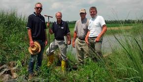
L-R: Sam Owings, High Impact Environmental; Cliff Stein, Earth Data Inc. Soil Scientist; Carl Robinette, NRCS Soil Scientist (Ret.); Eric Flickinger, Earth Data Inc. Director of Geospatial Services
The design guidance manual will include parameters for siting and sizing of the practice, as well as identifying opportunities for marketing nutrient offsets and credits resulting from this practice. This project will also address general operation and maintenance requirements that involve periodic inspections and typical repairs of critical components. Key design elements of the linear step-pool system will include the ability to create a fore-bay to contain the suspended sediments for ease of maintenance; optimum length-to-width ratio considerations to maximize the flow path; use of gravel bars or baffles to extend the time of concentration; and a needs assessment for a bypass system or a floating weir to limit the influx from large storms which may cause re-suspension of suspended pollutants.
“The ultimate goal of this project is to receive verification of the Cascading System of Floodway Stormwater Containment Basins as an innovative agricultural conservation practice,” according to Earth Data president Mark Williams. “The verification process certifies that a practice results in efficient reduction of nitrogen, phosphorous and sediment pollutant loads. The design guidance manual will be a tool which will allow this practice to be predictably duplicated by providing general requirements for preparing plans and specifications, sizing the linear step pools, typical plan views and profiles, typical erosion control measures, and general construction sequences and specifications.”
For more information, please contact Earth Data Incorporated – 410.758.8160; [email protected]
..


Write a Letter to the Editor on this Article
We encourage readers to offer their point of view on this article by submitting the following form. Editing is sometimes necessary and is done at the discretion of the editorial staff.