

I recently listened to the very interesting interview that the Talbot Spy recently aired with city planner Chris Jakubiak regarding the developments around Easton Point and its long-beleaguered waterfront. I applaud the efforts of the Easton Economic Development Corporation, and their hopes to build a link to the historic town core. This will prove to be a challenge but could be made much easier if the town of Easton would revamp its zoning ordinance and modernize with a new “form-based zoning“ approach.
As anyone may have gathered from the interview, Chris Jakubiak is a terrific guy, a skilled planner, and he has a very good sense of design. Unfortunately, the Eastern Shore, Easton, and many of its town administrators and lawyers are time-trapped in a 1960s outdated zoning bubble that continues to do serious damage to historic communities.
Much of this administrative dysfunction in towns is tied to ancient planning and zoning practices that are forty years out of date, and that create more systemic problems than they solve. I’ll go on to explain.
A few years back, Chris was involved in creating the first “form-based zoning” ordinance on the Eastern Shore in Cambridge and benefited from form-based zoning in their downtown core and along their extensive waterfront. Many had never heard of form-based zoning, and most would not know the terminology unless one had studied planning, were planning professionals, or took a strong interest in zoning administrative tools. The project is referenced below for those who may be interested.
“Form-based zoning” is defined as:
“A form-based code is a land development regulation that fosters predictable built results and a high-quality public realm by using physical form (rather than separation of uses) as the organizing principle for the code. A form-based code is a complete four-tiered regulation, not a mere guideline, adopted by city, town, or county law.”
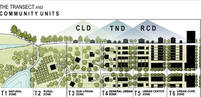
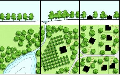
Typically form-based zoning has four parts 1) a regulating plan (a working town master plan) , 2) building placement standards ( where specific types of buildings go, their height, width, massing and appearance requirements) 3) streetscape standards (landscape details, lighting, paving and street width requirements) and 4) architectural design standards (specific building materials and details that are specified and required). Together these four parts create a proactive minimum standard three-dimensional model. These standards can be used for infill of vacant land or development extension of towns that are compatible with the existing historic town character.Failure to implement these form-based planning ordinances only creates more and more commotion in towns, and undercuts the quality of the built townscape.
Under current zoning regs, towns let a developer create its own interpretation of a two-dimensional model. Typically a town’s better citizens who fear for town character sound the battle cry at public meetings, create an uproar, dig deep into their personal pockets, spend enormous time and resources, and incur legal fees, to bring a new development up to base standard. This is not a good approach and creates enormous disharmony and resentment in communities.
 Typically developers, adept at “working” towns, first approach design with their worst versions of development. As the rancor builds and complaints are aired in public meetings, they yield small concessions, making it appear that they have listened to and worked with the town to make their development compatible. In truth, developers know exactly how much they can push towns. They make concessions only after the public has yielded big-ticket items. Developers know exactly how to get what they want, and it’s all orchestrated up front.
They know the townspeople begin at a serious disadvantage and unless the townspeople are backed by very deep pockets to pay lawyers to stall out development, developers usually get their way.
Developers are keenly aware who will rise to battle them and how well moneyed their opposition will be. It’s a game of money and legal maneuvering, and most local lawyers are all too happy to help. Even though one side always loses, the lawyers always win big fees.
Somehow the embattled citizens who have paid dearly never fault the town, never cite the town for liability for leaving the zoning code so wide open to this kind of predatory behavior. Recently the town of St. Michaels was nearly bankrupted by a zoning property rights error where a developer claimed his zoning density right to develop, and tried to double the size of the historic town. The town and its people fought the developer and ultimately it was a wealthy private citizen that saved the day ( and the town’s bacon) by buying out the developer.
Confrontations like this happen again and again, because people get tired of resisting. developers know this and keep coming at them.
Each battle the town character takes a ding, and each time town’s people become less likely to defend.
In this way, a town that does not use form-based zoning is leaving the town wide open to developer assault. Most people don’t know much about other zoning approaches, so no one demands these higher standards. Development is just viewed as a combative process that citizens usually lose by legal confrontation. Town planners simply play dumb even though they do know much better.
Most small to mid-sized Town planners won’t come forward with these new zoning models because 1) it’s an unpredictable rezoning process, takes a lot of time, resources and energy. Typically, change is unpopular, and if the process goes awry, planners could lose their jobs. 2) planners don’t know how to sell new ordinances to a skeptical public 3) the zoning administrators are not up to re-educating zoning commissioners to administer new ordinances 4) planners and surveyors are against this more user-friendly approach as because it reduces their professional fees. So it’s obvious there is no impetus for a head planner or city zoning administrator to attempt this big change unless there’s already a big popular outcry for it.
Having a minimum three-dimensional standard to argue from with form-based codes takes the pressure off of the public and puts it back on the developer to conform with this high minimum standard, not avoid it, or reinvent it. This comprehensive and compatible Minimum standard is why we need to have form-based codes. It makes being a citizen and a community so much less combative. It allows for better town infill additions, and it creates quality in a new development that would ordinarily be absent.
Jay Corvan is a Talbot County architect who specializes in historic work and commercial work, imaginative infill buildings that play on local architectural patterns.
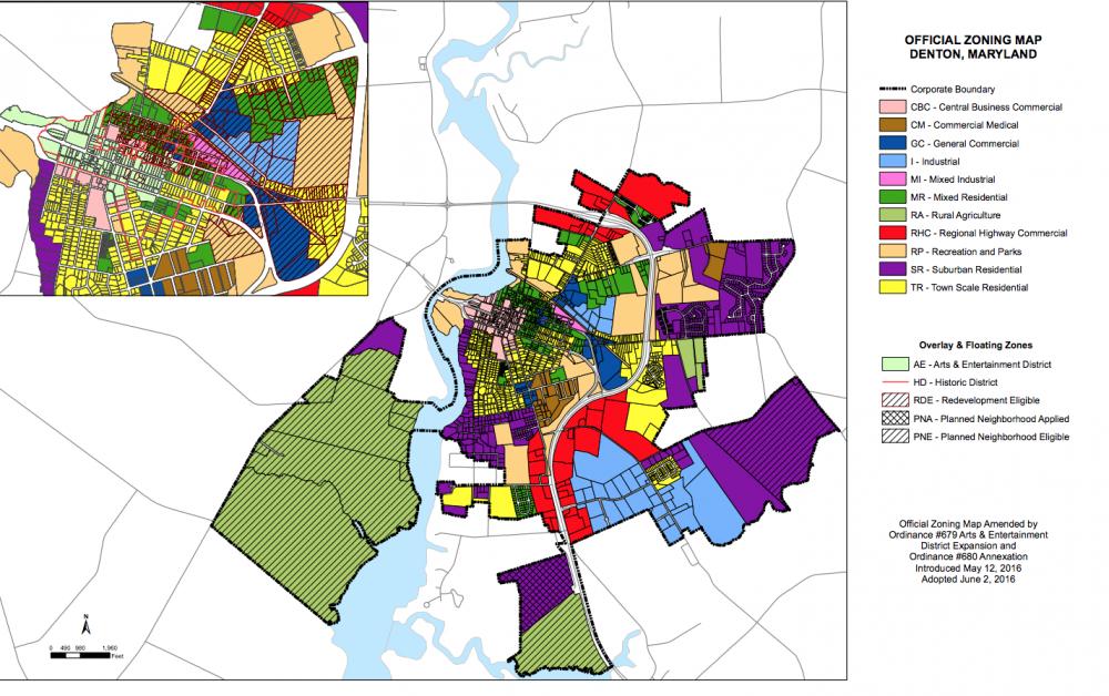
For more information about Cambridge’s use of form-based zoning please go here. To review the Denton Pattern Book please go here
Glenn Baker says
I’m hopeful because the lot sizes at Easton Point will not support development like that at the Dudrow Farm property, now Target, Harris Teeter etc. And acres of paved parking lots. And sadly nothing walkable anywhere.
Look to our Courthouse Square for enduring examples of livable spaces. Our read about and visit places like Kentlands in Gaithersburg, Md.
Jay Corvan says
Noticed the note by Glenn baker. I can’t help but say that we are already living in one of the best form based zoning communities. It’s our own historic town of Easton . If any part of this great town burned , like they used to do regularly , we could never rebuild them the way they were under current zoning codes.
That should tell you how wrong a zoning track we are on. This really has to change. And the sooner people realize it the more of the historic vote can be saved and revitalized.
Doug Davies says
I would encourage everyone to read the MXW Zoning ordinance that was passed last year for this area and comment on specifics that you feel may antithetical to achieving the kind of community you want to see at Easton Point. I too want a development pattern we can be proud of. There has been considerable effort already to shape this part of town, let’s start here, rather than at the basics. https://eastonmd.gov/EastonPoint/MXWZoningPCApproved.pdf
Barbara Denton says
While I understand the gist of your article it is running on the supposition that the surrounding neighborhoods to Easton Point want it developed. They do not. The plan which was published last year will ruin a lot of the surrounding neighborhoods. We do not understand why the County Council approved the annexation of this property into Easton. We do not understand why the Easton Council totally ignored concerned by noise, air and water pollution to approve this development. We do not understand how a piece of property supposedly located in a critical area can be developed so intensely and with little recognition if any of what the ecological ramifications of messing it up are. Easton had a waterfront years ago and they chose to fill it in and build on top of it. Every time you ride over the 322 and 33 intersection you are riding over a portion of the filled in North Branch of the Tred Avon.
It is unfair and wrong to develop this area so “Easton can now have a waterfront”. Easton gave that up a long time ago. The wishes of a dead mayor pale in comparison to the damage to property values, noise pollution, light pollution and traffic noise will do to surrounding neighborhoods. Greed on the part of developers is totally misplaced. Easton will never be the Hamptons of the Mid-Atlantic.