

Across the watershed, scientists and city officials are preparing for a rainy day — one that delivers cresting storm surges, whipping winds and so much water that it turns the streets into rivers. That is, a rainy day that delivers exactly what Hurricane Sandy gave much of New Jersey and New York City.
But for a slight turn in the super-storm’s path, Sandy would have hammered the Eastern Shore of Maryland and Virginia instead of New York and New Jersey, where it killed more than 100 people. Many neighborhoods in downtown Baltimore and Annapolis could have been underwater. And the Hampton Roads area, which floods even in small, unnamed storms, could have lost critical shipping and defense infrastructure.
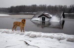
Except for Crisfield and Tangier Island, which suffered devastating floods and have been turned down for federal emergency aid, most of the Chesapeake Bay watershed escaped Sandy’s wrath. But those who track climate change and sea-level rise know that one day the Chesapeake region won’t be so lucky.
Sea level is expected to rise 2–5 feet over the next century, according to the Chesapeake Bay Program’s Science and Technical Advisory Committee.
“There weren’t necessarily any epiphanies from Sandy,” said Maryland Department of Planning Secretary Richard Hall. “Just more proof.”
Storms like Sandy are becoming more intense because of climate change. Greenhouse gas emissions warm Earth, melting the polar ice caps and warming ocean water temperatures. The melting ice adds water to the seas, and as water warms it expands, causing sea levels to rise.
A less understood factor in the sea-level and climate-change equation is the worldwide ocean circulation system, also known as the ocean conveyor belt. The conveyor belt starts at the Norwegian Sea, where warm water from the Gulf Stream heats the atmosphere. The loss of heat to the atmosphere makes the water cold and dense, according to National Oceanic and Atmospheric Administration’s ocean service. As more warm water travels north, the cold water sinks to make room for it as the belt travels to the South Pole and then to the Indian Ocean. Slowly, the cold waters rise and the 1,000-year cycle begins again.
The melting polar ice caps add more freshwater to the system, making the ocean waters less dense and altering circulation. That change means that water levels will rise in places where few expected they would, according to John Boon, professor emeritus of marine science at the Virginia Institute of Marine Science. Key West and Charleston, SC, are less at risk than Boston and Portland, ME.
Boon has been working on a model to predict the storm surges and water levels in the Norfolk area. His information showed that Sandy wouldn’t wallop the city. But Hampton Roads residents can see that it’s a matter of time before their turn comes.
Norfolk began crafting its flood-protection system in 2007. Officials plan to spend about $150 million to install tide gates, part of $1 billion to protect an area that is home to some of the nation’s most important defense and railway infrastructure. But officials don’t know how they will fund the projects.
The planning has led to a sea change in how the region perceives the problem, said James Koch, an economist and former president of Old Dominion University. Koch, who delivers about 50 speeches a year in the region, said his conservative audiences no longer deny that the water levels are rising. And city planners, who once concealed flood maps from citizens, are making them public.
“There’s much less carping and hee-hawing that this is junk science,” Koch said. “Very few people in this region now doubt that sea level is rising and is something we should be concerned about. It’s almost to the point of, if you don’t agree to that, you’re regarded as a dummy.”
New York City Mayor Michael Bloomberg is talking about fortifying neighborhoods with dunes, levees, jetties and berms. At press time, estimates for damage from the storm topped $40 billion for state of New York alone.
Annapolis, MD, is looking at controlling the flooding at City Dock. Frank Biba, chief of the city’s environmental program, said the latest proposal is to build “a seawall that doesn’t look like a seawall.” Until then, Biba is looking into placing backflow valves on the stormwater pipes to stem the flooding.
In Baltimore, city public works crews spend much of their time addressing aging infrastructure, which can lead to flooding even in minor storms. The city has a strategic plan to replace its aging pipes and plans to address the effect of higher water levels on the stormwater system.
Sandy did not spare Crisfield, MD. It destroyed homes, businesses and a dock for the boats that make daily trips to Smith and Tangier islands. The boats deliver mail and food, and take students to high school and workers to mainland jobs. The Federal Emergency Management Agency turned down the Eastern Shore city’s request for funds, leaving the city uncertain as to how it will rebuild.
Tangier Island, at least, got good news: The U.S. Army Corps of Engineers will help build a long-awaited jetty and seawall that will protect the island’s channel and harbor, as well as shield the island from wave impact and erosion. The project will cost $4.2 million.
Learning from Isabel
For many Bay towns, Hurricane Isabel nine years ago, not Sandy, was the wake-up call.
The coast of Virginia has regularly battled with the elements since a 1933 hurricane that delivered a storm surge of 5.84 feet in Hampton Roads. But after the Ash Wednesday storm of 1962, it entered a relatively quiet period, Boon said.
By the time Isabel slammed into Hampton Roads in 2003, sea level had risen more than one foot in the intervening 70 years. Isabel’s storm surge in Norfolk was recorded at 4.76 feet, making it as devastating as the 1933 hurricane.
“That was when things really struck home,” Boon said. “They don’t have to be as big as the 1933 storm anymore.”
Of the eight major tidal events since 1933, five have occurred in the last decade. Hampton Roads must also contend with a rapid rate of land subsidence because it was built on the Chesapeake Bay Impact Crater, the dent in the Earth left by an ancient meteor. The land is slipping into the crater, and the removal of groundwater for the many industrial activities is accelerating that process.
William Boicourt, an oceanographer at the University of Maryland’s Horn Point Laboratory, is hoping that sticker shock over Sandy’s rebuilding costs will persuade Congress to fund an early-warning system that he and a dozen other scientists developed several years ago. The Chesapeake Bay Inundation System combines tide data, wind speed and computerized weather models to more accurately predict flooding. NOAA funded the system’s development, but the agency didn’t have the money to let the group run their model.
Boicourt is hoping to receive $1.8 million to get the system up and running. He wants to use it as a model for the East Coast and the Gulf Coast, and then be able to expand the range for the entire country.
But, Boicourt acknowledged, “It’s hard to get money for that ounce of prevention.”
It’s also hard to stop developers from building in flood-prone coastal areas. Even though major insurers have pulled out of Virginia’s coast, the Northumberland County Board of Supervisors approved a massive home-spa-marina complex on a flood-prone peninsula.
“Many of the builders want to discount the scientific evidence that sea level is rising, and that the land that they are selling or wanting to develop could be under 10, 11 or 12 inches of water or more in the next decades,” said Mike Tidwell of the Chesapeake Climate Action Network. “I think we need to have science drive much more of our planning for building along the coast so that we at least prevent new building in endangered areas.”
For residents returning home to the New York and New Jersey coast, it’s a difficult calculation. With the exception of the Army Corps of Engineers, almost no federal agency is taking into account sea-level rise when writing their guidelines, according to Skip Stiles, the founder of Wetlands Watch, a Norfolk-based group.
“You can’t not allow someone to rebuild where they were before,” he said.
But Sandy may finally be the storm that broke the developers’ back. Even in New York, where coastal real estate remains at a premium, it won’t be business as usual.
“We are not going to abandon the waterfront,” Bloomberg said at a recent news conference. “We are not going to leave the Rockaways or Coney Island or Staten Island’s South Shore. But we cannot just rebuild what was there and hope for the best.”
By Rona Kobell
Bay Journal News Service
..
Write a Letter to the Editor on this Article
We encourage readers to offer their point of view on this article by submitting the following form. Editing is sometimes necessary and is done at the discretion of the editorial staff.