


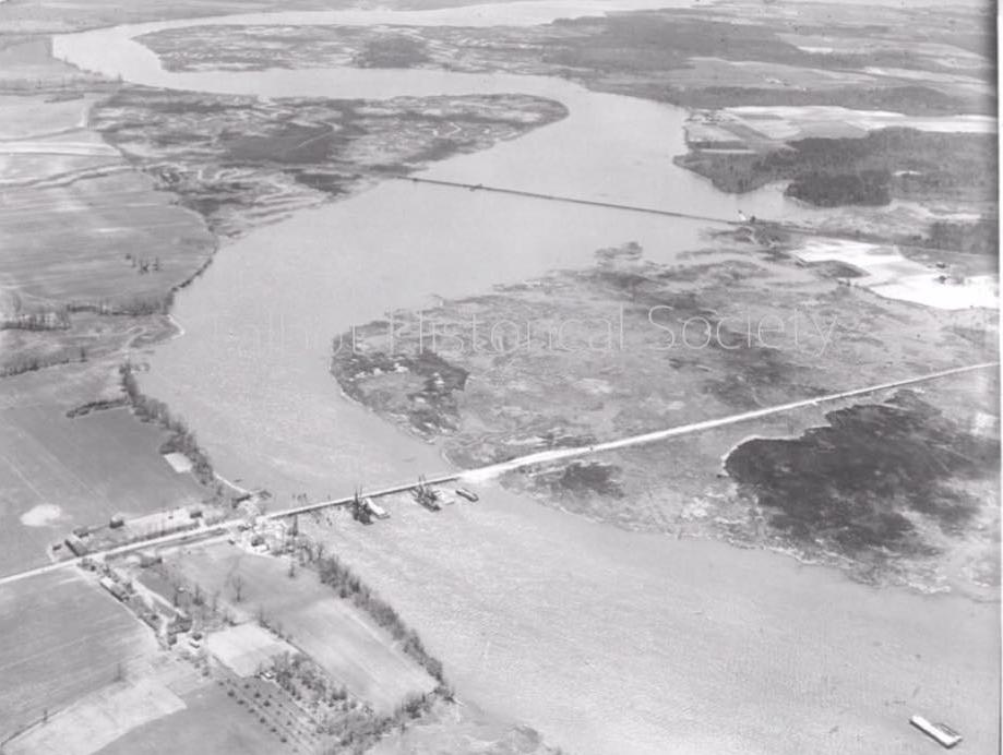
Talbot County: Aerial view of Dover Bridge over the Choptank River with the railroad bridge in the background. This undated Talbot Historical Society H. Robins Hollyday Collection photo raises questions about where the track and railroad bridge ran on the Talbot County side? Near Kingston Landing? Is that Kings Creek weaving inland near the railroad bridge?
Contact: Cathy Hill [email protected] to share your old photos. Comment, Like our page and join THS!
..
Charles Adler says
The Historical Society should contact Dr. Michael Scott at [email protected].
Dr. Scott has used LIDAR (elevation data) to extract old railroad track beds in near sea level landscapes. Please use the following link as an example of the relevant data type:
https://www.arcgis.com/home/webmap/viewer.html?webmap=262128fb43f44dbca15647e57d4822a9&extent=-76.6412,38.5277,-75.627,38.993
Mr. Mark Cohoon with Talbot County Planning, GIS Department is an excellent local resource.
Happy Holidays and thanks Talbot Spy.
Jacques Baker says
Is it possible that this photograph has been printed in reverse? I believe that the railroad bridge in the picture crossed the Choptank River south of the Dover Bridge (which appears to be under construction in the photo). If that is the Cober farm in the lower left-hand corner of the picture, I think it is actually on the north side of Dover Road .
D B says
At the Easton Library, in the Maryland room, they have a huge collection of old insurance maps. They can show you exactly where the rails went all over the shore. Or you can google “Sanborn Fire Insurance maps” and type in Easton and search around. Kinda clunky though. I don’t have enough time to search myself tonight.
Another wonderful resource is “Rails along the Chesapeake”, by John C Hayman. They also have a copy in the Maryland room. Sadly it lacks detailed maps, but makes up for it in tons of well researched information, and photos about our wonderful, and sadly disappearing railroad history.
I mean how nice would it be to hop on a train in Easton and end up in Baltimore? Or Ocean City? Or hop on a little trolley to go to Oxford/St Micheals for the day.
Mark Cohoon says
It took me a little while to figure this one out, a real brain teaser. The black and white negative was developed upside down. The photo is taken from the north looking south and the tracks come through Talbot County near the landfill and through the Easton Wastewater Treatment Plant property.
Steve Bradley says
As others have suggested—the photo should be flipped horizontally: farmland on the right and the marshes on the left. If you look at Google Earth, you can see where the railroad had come out of Easton and across the Tuckahoe. There is a dirt road and the remants of one closer to the river where the tracks were that are still (fairly) obvious.