

It’s no secret that the health of the Chesapeake Bay ecosystem and its valuable blue crab and striped bass fisheries have been under threat from the region’s growing population and expanding economic activity. But a recent ShoreRivers report on improving water quality in some parts of the Eastern Shore of Maryland seems to suggest a positive trend. This is a story about actions leading to that trend, in which a U.S. National Oceanic and Atmospheric Administration (NOAA) laboratory located in Oxford, Maryland, has played a key role.

Agricultural land use dominates some parts of the Choptank watershed and is a major source of sediment and fertilizer runoff that contributes to poor water quality which may harm economically important fisheries. Source: NOAA
The seriousness of the environmental threat to the Bay’s fisheries was confirmed by a 2015 NOAA scientific study and a number of earlier studies that documented impaired water quality and poor biological health. A primary cause of the degradation, the studies found, was transformation of the natural landscape by agricultural activity and urbanization in ways that increased runoff into streams and rivers: runoff of sediment, nutrients such as fertilizers, and chemical and bacterial pollutants. The result is murky water, reduced underwater vegetation, and declining numbers of fish, crabs, and oysters coupled with increased levels of bacteria, fish disease, and fish parasites. The pattern of degradation seemed to track the types of predominant local land use, whether urban, agricultural, or forest.

NOAA scientists from Cooperative Oxford Laboratory pull a seine net in fish community composition sampling for the Tred Avon River ecological assessment. Source: NOAA
Since 1983, the Chesapeake Bay Program has been working to improve the Bay. The latest agreement, signed in 2014 by six states, the District of Columbia and the EPA on behalf of seven federal agencies, committed to achieving a long list of measurable outcomes and improvements. Included in these are water quality targets to reduce sediment and nutrient runoff and to restore native oyster habitat and populations in 10 tributaries, 5 in Maryland and 5 in Virginia, by 2025. (Oysters filter and thus help clean the water).
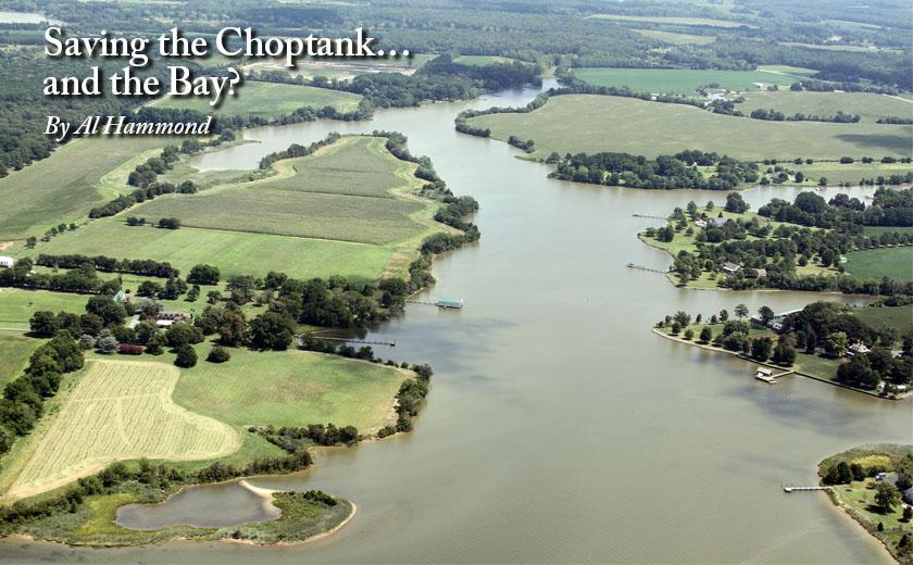
Also in 2014, NOAA designated the Choptank River—the longest and largest river that empties into the bay and a key blue crab producer—a habitat focus area. As part of the overall Choptank effort, NOAA initiated a detailed scientific assessment of one of the river’s tributaries—the Tred Avon River that flows from Easton to where it empties into the larger Choptank near Oxford.
The study—conducted by NOAA’s Cooperative Oxford Laboratory—was a massive effort. Dr. Shawn McLaughlin, who directed the research, says it involved repeated sampling and data collection: “For three years we conducted daily, weekly, or monthly field trips to river sites in eight Tred Avon sub-watersheds spanning forested areas, agricultural lands, and urban areas.” The scientists measured water clarity and dissolved oxygen levels, concentrations of nitrogen and other nutrients, the presence of underwater vegetation, and numbers and types of fish and their health—including seasonal patterns. The resulting 2018 report documents the impacts of different land use patterns on water quality and fisheries health and suggests management practices that could help mitigate damage and restore ecological condition. The findings include:
- Urban areas such as Easton, with their abundance of paved surfaces, are a major source of runoff, leading to higher levels of chemical contaminants, nutrients, and fecal bacteria as well as low dissolved oxygen levels in nearby bottom waters and the absence of many fish species during high summer temperatures.
- Agricultural areas also showed high levels of nutrients and poor water clarity (which affects underwater vegetation that provides shelter and food for fish).
- Watersheds dominated by forests had relatively good water quality and abundant fish and shellfish species.
The report pointed out the need for continuing efforts to reduce nutrient and sediment runoff across the entire ecosystem and the importance of preserving critical habitats for fish and shellfish, especially in spawning areas such as the Choptank. It also calls for innovative management approaches such as planting or restoring oyster beds and setting thresholds for land development.
Concurrent with the research, as part of the overall Choptank effort, NOAA’s Chesapeake Bay Office initiated an effort to coordinate local organizations with similar goals to achieve more than would be feasible if they acted alone. While this “collective impact” strategy had proven itself at community-scale, attempting it on a much larger scale was a novel approach for NOAA. An experienced environmental consultant was hired to stimulate and coordinate local action by working with local governments, non-profit organizations, philanthropic donors, and other stakeholders such as ShoreRivers.

Sampling water quality as part of the Tred Avon Assessment. Source: NOAA
The consultant, Joanna Ogburn, brought many groups together and created Envision The Choptank (envisionthechoptank.org), a partnership focused on pairing the scientific findings with local knowledge and local actors to find collaborative solutions. It used preliminary data from the NOAA Tred Avon study along with other Chesapeake Bay Program studies and data to guide pilot projects, get people excited about what was happening, and promote best practices among county officials, farmers and individual homeowners. The organization also hired coordinators to work with landowners 1-to-1, raised funds to provide incentives, and linked landowners to technical assistance. The Envision partner organizations have helped to engage many different entities, share tools and information and ideas, and coordinate strategies and funding efforts.
The effort has paid off. It enabled McLaughlin and her research team to meet with local, state and federal officials to share the evidence connecting land use to the condition of the aquatic ecosystem. It brought the laboratory together with Easton officials, Talbot county government and public works representatives, and ShoreRivers to discuss ways to “green” the proposed Port Street development in Easton by minimizing additional impervious surfaces that would intensify runoff. Envision partners also identified two stream restoration projects within the urban area and provided the Town of Easton with a small grant to design the projects, which led to a larger state grant to fully fund the work.
In another example, Envision partners engaged residential landowners to reduce storm water drainage. Using locations in the lower Choptank that the Oxford data showed regularly had low water quality, they got the Nature Conservancy to do digital map studies to determine the lands draining to those locations, then invited all the relevant landowners to workshops. There they taught residential homeowners how to build rain gardens and other techniques that improve water quality and the attractiveness of their properties. Envision partners have used the same strategy to identify agricultural landowners that are significant sources of runoff, so that they can reach out to them.
More than 35 organizations are now involved with Envision the Choptank, which is now expanding its efforts across the entire Choptank ecosystem. It organized a $1 million grant from the National Fish and Wildlife Foundation to engage, incentivize, and work with farmers in creating buffers and other strategies to manage runoff. Joanna Ogburn comments that “This grant is helping us launch a new wave of interventions. We’ve been able to build financial incentive programs to overcome the challenges landowners and farmers face in implementing restoration practices. We’re hoping to engage landowners in the Choptank watershed in creating buffers, wetland restoration, and drainage ditch management practices, ultimately restoring 230 acres.” And, as the latest ShoreRivers report suggests, these actions—at state and county and local levels—are beginning to show results.
It’s clear that the research and the scientific data it produced were critical in persuading both public officials and individual farmers and homeowners to get involved and take action. But it’s also clear that communication efforts and coalition building to find and implement local solutions were equally important—and that the Cooperative Oxford Laboratory played a central role in both. Suzanne Skelley, director of the lab, noted “Using research results to inform decision-making, especially to improve ecosystem condition while enhancing community resilience, is a core mission of the Lab and of NOAA.” The winning formula for saving the Choptank, and perhaps the broader Chesapeake Bay ecosystem, seems to be: science + communication/engagement + local action.
Al Hammond was trained as a scientist (Stanford, Harvard) but became a distinguished science journalist, reporting for Science (a leading scientific journal) and many other technical and popular magazines and on a daily radio program for CBS. He subsequently founded and served as editor-in-chief for 4 national science-related publications as well as editor-in-chief for the United Nation’s bi-annual environmental report. More recently, he has written, edited, or contributed to many national assessments of scientific research for federal science agencies. Dr. Hammond makes his home in Chestertown on Maryland’s Eastern Shore.

Write a Letter to the Editor on this Article
We encourage readers to offer their point of view on this article by submitting the following form. Editing is sometimes necessary and is done at the discretion of the editorial staff.