MENU

Sections

  • Home
  • About
    • Contact Us
    • Editors and Writers
    • Join our Mailing List
    • Letters to Editor Policy
    • Advertising & Underwriting
    • Code of Ethics
    • Privacy
    • Talbot Spy Terms of Use
  • Art and Design
  • Culture and Local Life
  • Public Affairs
    • Ecosystem
    • Education
    • Health
    • Senior Life
  • Community Opinion
  • Sign up for Free Subscription
  • Donate to the Talbot Spy
  • Cambridge Spy

More

  • Support the Spy
  • About Spy Community Media
  • Advertising with the Spy
  • Subscribe
May 20, 2025

Talbot Spy

Nonpartisan Education-based News for Talbot County Community

  • Home
  • About
    • Contact Us
    • Editors and Writers
    • Join our Mailing List
    • Letters to Editor Policy
    • Advertising & Underwriting
    • Code of Ethics
    • Privacy
    • Talbot Spy Terms of Use
  • Art and Design
  • Culture and Local Life
  • Public Affairs
    • Ecosystem
    • Education
    • Health
    • Senior Life
  • Community Opinion
  • Sign up for Free Subscription
  • Donate to the Talbot Spy
  • Cambridge Spy
3 Top Story

Drawn Out of 1st District, Harden Mulling a Move to the Eastern Shore

December 16, 2021 by Maryland Matters

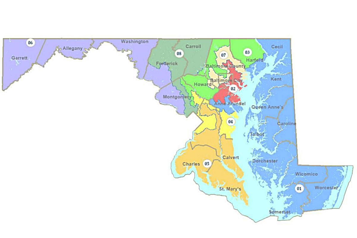
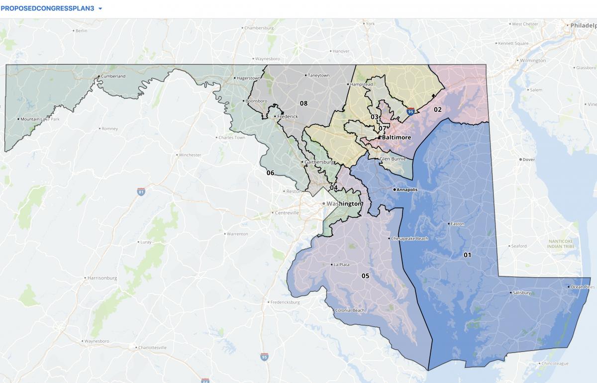
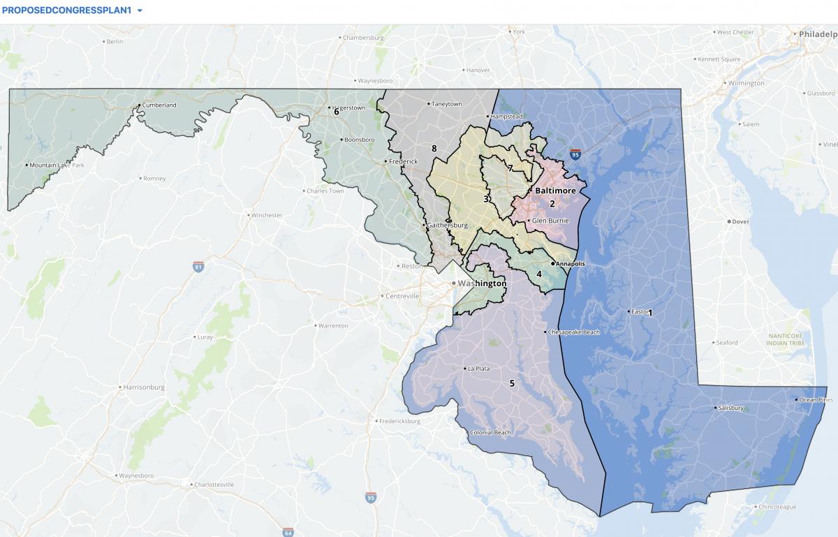
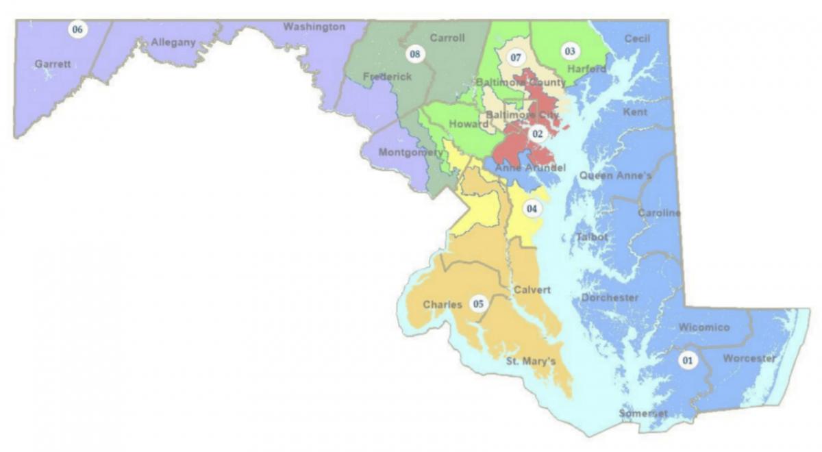
Maryland’s 1st Congressional District underwent a vast transformation in the most recent round of redistricting: It once extended through northern Harford County into parts of Carroll and Baltimore counties, it now includes a southern section of Harford as its northern terminus and extends across the Chesapeake Bay Bridge to include parts of Anne Arundel County.

That means the district will be significantly more competitive in 2022. It also means that some running for that congressional seat have been drawn out of the district, including incumbent U.S. Rep. Andrew P. Harris, the state’s lone congressional Republican who lives in Cockeysville, which is now split between the 2nd and 7th congressional districts.

The U.S. Constitution requires representatives to live in the state they represent, but not the same district.

R. David Harden, one of three Democratic contenders vying for a chance to unseat Harris in 2022, said he’s looking to move anyway. Harden’s current home is near Westminster in Carroll County. The previous map put Harden, a foreign policy strategist, in the 1st District, but the new one puts him in the 8th District. He said in an interview that he’s “actively looking for a place on the Eastern Shore.”

But he said that he wants to see whether litigation might shake up the newly drawn district lines before making a move. Fair Maps Maryland, an anti-gerrymandering group with ties to Gov. Lawrence J. Hogan Jr. (R), vowed legal action against the General Assembly’s congressional map just moments after it passed the state Senate during last week’s special session.

“The uncertainty of that, though, is weighed against the fact that this district is perfect for me,” Harden said.

Harden sees opportunity in the newly drawn 1st District. The district was redrawn in 2012 to be heavily conservative, allowing for a Democratic-leaning 6th District in Western Maryland, and Harris handily won reelection. But the new lines have put the 1st District into toss-up territory, and Harden hopes that he’ll be able to capture votes from both Republicans and Democrats by positioning himself as a moderate.

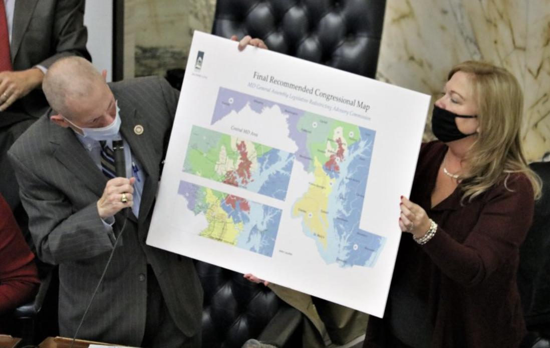
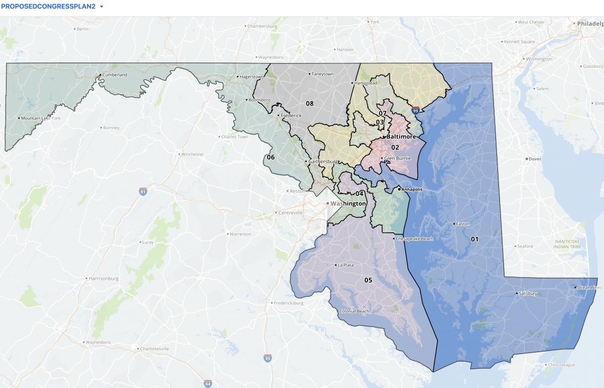
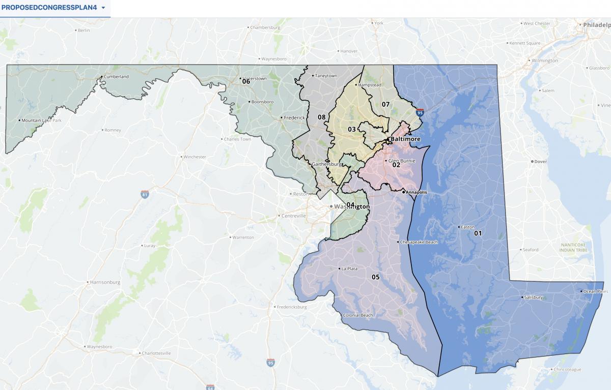
The congressional map adopted by the General Assembly. Screenshot.

Harden expects to face Heather R. Mizeur in the Democratic primary next year. Mizeur, formerly a state delegate from Montgomery County, now lives in Chestertown on the Eastern Shore. She has already broken early fundraising records in the 1st District. Jennifer Pingley (D), a registered nurse who lives in Cecil County, also is vying for a chance to unseat Harris.

The new 1st District includes more than 200,000 residents of central Anne Arundel County. Harden hopes that area’s proximity to military bases and government contracting firms will allow him to flex his foreign service experience and appeal to voters there.

“They’re moderate folks,” Harden said. “They care about education, they care about economic opportunity, they care about crime, security and stability.”

Harden hopes to use his rural upbringing and ancestral ties to the several parts of the district to appeal to voters. He said both of his parents trace their family history back to the Eastern Shore, and that his father’s side of the family later moved to Anne Arundel County near the Severn River.

Harden noted that Democrats have struggled to win rural districts in recent years. 2022 is showing signs that it could be a particularly tough year for Democrats in rural areas after Republican Glenn Youngkin swept rural counties in Virginia during that state’s November gubernatorial election.

“Whatever the Democrats have been doing in rural America, the Democratic strategy for rural America has failed,” Harden said. “We need to be competitive in rural counties. And that means that we have to understand the hopes and aspirations, the challenges and the grievances of rural counties.”

Mizeur is a prominent progressive who had garnered a significant backing before the district was redrawn — and she has been endorsed by Wayne Gilchrest, a moderate Republican and longtime 1st District representative.

And Mizeur’s farming background isn’t anything to write off, either: She grew up in Blue Mound, a village in rural Macon County, Illinois, and now lives on an organic farm in Chestertown. According to her campaign, her family has been farming for seven generations.

“Winning – and representing the people here – requires an ability to build coalitions, work with people across the political spectrum, and solve problems with pragmatic solutions,” Mizeur said in a statement. “That has been my calling card for years, and it’s the reason my campaign has garnered support from a wide range of leaders – from former Republican Congressman Wayne Gilchrest to House Majority Leader Steny Hoyer, or from local leaders like Salisbury Mayor Jake Day to former Queen Anne’s County Republican Commissioner David Dunmyer, just to name a few.”

Harden said he thinks the Democratic challenger to Harris in 2022 will need to garner votes from “centrist Democrats, independents and Hogan Republicans” to have a realistic chance of winning.

Appealing to rural voters, including watermen and farmers, is set to be a key aspect of both Harden’s and Mizeur’s campaigns. Mizeur recently rolled out a “Farmers for Mizeur” group and outlined a plan to include farmers in the fight against climate change. Harden has said the Eastern Shore and the Chesapeake Bay should be a proving ground for technologies that, likewise, will combat climate change.

The 2022 primary election will be held on June 28, 2022. Learn how to register to vote here.

By Bennett Leckrone

The Spy Newspapers may periodically employ the assistance of artificial intelligence (AI) to enhance the clarity and accuracy of our content.

Filed Under: 3 Top Story Tagged With: andy harris, Congress, districts, first district, heather mizeur, Maryland, r. david harden

“We Know Nothing”: Lawmakers to Probe Attack That Took Down Agency’s Computers

December 15, 2021 by Maryland Matters

Two legislative committees that oversee the Maryland Department of Health plan to grill state officials about an attack that disabled the agency’s computers, top lawmakers said on Tuesday.

Gov. Lawrence J. Hogan Jr. (R) has revealed little about the Dec. 4 attack, which has significantly hampered the agency’s operations.

Health department employees initially were told to stay off their computers as a precaution. Although some systems have come back online, the agency has not posted COVID-19 case rates, testing or mortality data since Dec. 3.

Hospitalization and vaccine data are available, as are congregate and school outbreak reports. Maryland is experiencing its biggest spike in hospitalizations since April.

“The governor has been incredibly quiet about this issue,” said Del. Shane Pendergrass (D-Howard), head of the House Health and Government Operations Committee. “The question of how it happened, why it happened, how bad is it — all of those things need to be answered.”

Senate Education, Environment and Health Affairs Committee Chairman Paul G. Pinsky (D-Prince George’s) accused Hogan of being “absent.”

“He’s always out front when there’s good news — even it’s not because of his actions. But when there’s bad news, he’s not in front of the cameras,” the lawmaker said. “They shouldn’t duck this. They should say what the problem is [and] how long it’s going to take to fix it.”

“We know nothing” about the impacts the attack is having, Pinsky added, including whether hackers have sought a ransom payment, a common tactic.

Hogan’s office initially did not respond to requests for comment on Tuesday, and a Maryland Department of Health spokesman declined a request for an interview.

The agency also refused to answer written questions about whether the attack originated overseas, whether a ransom has been requested, whether employees are able to use their government-issued computers, how operations have been impacted, who is handling the investigation, or whether Health Secretary Dennis Schrader intends to testify at the legislature’s hearing.

The morning after this story was initially published, Hogan spokesman Michael Ricci sent a brief statement: “We fully briefed legislative leaders last week, and we will continue to provide information to legislators and constituents to the extent possible without compromising the ongoing investigation.”

At a press conference last Thursday, Hogan said, “Our system was compromised, but at this point it appears to be much, much less intrusive and with a much better outcome than we were afraid might be the case.”

“We don’t believe that any data was sacrificed, and I think they’re digging into it and getting into the problem,” he added.

On July 1, the state reported 97 COVID patients in Maryland hospitals. On Tuesday, there were 1,173, the most since April 22.

Anne Arundel officials reported Tuesday that there are 84 COVID patients in county hospitals, up from approximately 40 last week.

“It is concerning to have a doubling of our hospitalization in the last week and not know what our case rates look like right now,” County Executive Steuart Pittman (D) told reporters. “Not knowing what’s going on with the case rates means that [hospitals] can’t project what their hospitalization rates are going to be in two weeks.”

Most of Anne Arundel’s sickest COVID patients had not been vaccinated, Pittman said.

Anne Arundel Fire Chief Trisha L. Wolford said hospitals are “absolutely struggling” — as are her paramedics.

“The waits are incredibly long,” she said. “When they’re at the hospital for multiple hours, it’s heartbreaking that they can’t be out in the community.”

Wolford urged unvaccinated residents to “do the right thing for your community and your neighbors” by getting their shots.

In a statement, state health department spokesman Andy Owen said the agency “took down certain systems out of an abundance of caution following the recent network security incident.”

The agency’s priorities are “gaining full visibility into the affected network infrastructure,” bringing systems back online, and restoring full COVID-19 data reporting capabilities, he said.

Pendergrass has scheduled a hearing into the computer attack for Thursday, Jan. 13, the first full day of the legislature’s 2022 session. She and Pinsky have agreed to hold one together but Pinsky wants to hold it in December.

Regardless of when lawmakers hold their hearing, “the governor will not likely take responsibility for this, nor will anyone else,” Pendergrass said. “The administration is not ever very forthcoming about anything, in particular the Health Department.”

By Bruce DePuyt

The Spy Newspapers may periodically employ the assistance of artificial intelligence (AI) to enhance the clarity and accuracy of our content.

Filed Under: Maryland News Tagged With: attack, coronavirus, Covid-19, data, general assembly, health department, Maryland, network

Md. General Assembly Overrides Gov. Hogan’s Veto of Congressional Redistricting Plan

December 10, 2021 by Maryland Matters

Heading into the special session this week, two congressional redistricting proposals were on the table: one put forward by Democratic legislative leaders’ Legislative Redistricting Advisory Commission, and another from Republican Gov. Lawrence J. Hogan Jr.’s Maryland Citizens Redistricting Commission.

On Monday, lawmakers advanced the Legislative Redistricting Advisory Commission (LRAC) proposal out of the House Rules and Executive Nominations Committee and didn’t move the Maryland Citizens Redistricting Commission (MCRC) redistricting plan forward.

On Tuesday, the House of Delegates approved the LRAC proposal following an unsuccessful attempt by Republicans to amend it by replacing its map with the map proposed by the MCRC.

On Wednesday, the Senate passed the LRAC redistricting plan after Republican senators made a similar attempt to amend it.

Gov. Lawrence J. Hogan Jr. (R) pushes a veto stamp onto the congressional redistricting proposal passed by the Democratic supermajority in the General Assembly. Photo by Danielle E. Gaines, Maryland Matters

On Thursday, Hogan vetoed the LRAC redistricting plan at a press conference at 2:15 p.m.

And the General Assembly swiftly overrode Hogan’s veto, roughly an hour and a half after he announced it. The House voted 96-41 in favor of an override, the Senate supported the move 32-14.

Hogan’s veto was not a surprise. The governor had promised to oppose any redistricting proposal that differed from the one put forward by his Maryland Citizens Redistricting Commission, a panel that included three Republicans, three Democrats and three unaffiliated voters. Hogan appointed the three co-chairs of that commission.

Democrats hold a veto-proof majority in both the House of Delegates and the state Senate. And they also overrode Hogan’s vetoes of several measures from the 2021 legislative session during the special session.

Senate President Bill Ferguson (D-Baltimore City) and House Speaker Adrienne A. Jones (D-Baltimore County) convened the Legislative Redistricting Advisory Commission, which they are members of.

The debate over Maryland’s congressional maps won’t end with the override votes. Fair Maps Maryland, an organization with ties to Hogan, announced plans for a lawsuit challenging the congressional redistricting plan just moments after the state Senate approved it Wednesday evening.

Hogan said he opted to veto the maps Thursday rather than waiting until the end of the legislative session to “allow the court process to begin.”

On Monday, U.S. Attorney General Merrick B. Garland announced a lawsuit challenging the Texas’ redistricting plan that the state’s Republican-led legislature approved in October. Garland charged that plan would disempower Black and Latino voters.

Hogan echoed Sen. Stephen S. Hershey (R-Middle Shore), who suggested on Wednesday that Garland should also scrutinize the Maryland General Assembly’s redistricting plan.

“He needs to take a look at exactly what we’re doing here in Maryland with respect to the same reason that he’s suing the state of Texas,” Hershey said Wednesday.

The LRAC map includes two majority Black districts — the 4th and the 7th — and creates a 5th Congressional District with a Black plurality for a total of three districts with a majority people of color.

In the current congressional map, the 4th and 7th are majority Black and the 5th has a white plurality. The Maryland Citizens Redistricting Commission map would have included one majority Black district and three additional districts with a majority people of color.

“These gerrymandered maps will be challenged in both the federal and the state courts,” Hogan said Thursday.

The congressional map adopted by the Legislative Redistricting Advisory Commission. Screenshot from the Maryland General Assembly website.

Democratic lawmakers have defended the LRAC congressional map. Senate President Pro Tem Melony G. Griffith (D-Prince George’s), a member of the LRAC, said during Wednesday’s floor debate that the commission was “very mindful” of complying with the Voting Rights Act.

“I’m confident that we have provided the opportunity for minority voters to vote for their preferred candidate, as we intended,” Griffith said.

While Republicans have highlighted the fact that the MCRC aimed to minimize county splits in its congressional redistricting proposal, Democratic lawmakers have said compactness is secondary to compliance with the Voting Rights Act and minimizing population variances.

The legislative panel also aimed to keep as many voters in current districts as possible while the MCRC opted to not consider existing districts at all when drawing up maps.

“Maryland’s geography is unique, and our population is varied,” Senate Majority Leader Nancy J. King (D-Montgomery) said Wednesday. “Taking all that into consideration, I am confident that this map is a fair one, and one that reflects the lived experience of Marylanders.”

Just one Democratic lawmaker in either the House of Delegates or the Senate voted to sustain Hogan’s veto: Del. Gabriel T. Acevero (D-Montgomery). Acevero said in an interview that “gerrymandering is wrong no matter the party.”

Acevero said that, despite his objections to the LRAC map, he didn’t find the Maryland Citizens Redistricting Commission map any better.

“The commission was pretty much chosen by Hogan,” Acevero said. “It’s not independent.”

Acevero said all lawmakers and Hogan should support the federal For The People Act, which would require nonpartisan redistricting commissions across the country. That legislation, sponsored by Maryland Rep. John P. Sarbanes (D), passed the U.S. House of Representatives earlier this year but has been blocked by Republicans in the Senate.

“What we need is both parties calling on the U.S. Senate to abolish or reform the filibuster and pass the Freedom to Vote Act, which does away with partisan redistricting,” Acevero said. “I believe in democracy and I think the democratic thing to do is for senators to do their job.”

Asked if he had received or worried about blowback from his fellow Democrats, Acevero replied, “Come on, man. I’m always going to do what I think is the right thing.”

The General Assembly isn’t done with redistricting, either: Lawmakers will tackle state legislative redistricting when they return for their regular session in January. As with congressional redistricting, lawmakers will weigh proposals from both the MCRC and the LRAC.

The LRAC hasn’t released a legislative redistricting proposal yet.

Like the MCRC’s congressional proposal, that panel’s legislative redistricting proposal received an “A” rating from the Princeton Gerrymandering Project, which scored the plan based on competitiveness, partisan fairness and geographic features. The LRAC congressional map received an “F” based on those criteria. Democratic lawmakers took issues with Princeton’s scoring system because it doesn’t factor in Voting Rights Act compliance.

Constitutionally, Hogan can’t veto the General Assembly’s legislative maps, but his proposed maps become law if the General Assembly doesn’t pick an alternative within the first half of the 2022 legislative session.

By Bennett Leckrone, Josh Kurtz, and Danielle E. Gaines

The Spy Newspapers may periodically employ the assistance of artificial intelligence (AI) to enhance the clarity and accuracy of our content.

Filed Under: 3 Top Story Tagged With: Congress, congressional, Gov. Larry Hogan, Maryland, Maryland General Assembly, override, redistricting, veto

Hogan-Aligned Group Announces Plans for Lawsuit Against Just-Approved Congressional Redistricting Plan

December 9, 2021 by Maryland Matters

An organization with ties to Republican Gov. Lawrence J. Hogan Jr. announced Wednesday that it will seek to overturn the congressional redistricting plan approved by the Democratic supermajority in the General Assembly.

The announcement, from Fair Maps Maryland, came just moments after the state Senate followed the House of Delegates in voting to accept a map drawn by a legislative panel made up of four Democratic leaders, two Republican leaders and a non-voting former top staffer.

Under that map, crafted by Legislative Redistricting Advisory Committee (LRAC), Democrats would maintain electoral advantages in seven of the state’s eight congressional districts.

Many of those districts would be abstractly shaped, in keeping with the long practice of both parties to maximize the once-a-decade map-drawing process for maximum benefit.

The biggest changes from the state’s current congressional map involve the Eastern Shore-based 1st District, represented by Rep. Andrew P. Harris (R), a Trump-aligned conservative. It was refashioned by the Assembly to pull in portions of Anne Arundel County, giving it a roughly equal number of Republicans and Democratic voters.

The congressional map adopted by the Legislative Redistricting Advisory Commission. Screenshot from the Maryland General Assembly website.

In announcing its plan to sue, Fair Maps Maryland spokesman Doug Mayer said, “this level of gerrymandering is voter suppression.”

According to Maryland State Board of Elections voter registration statistics, about 55% of Maryland voters are Democrats and 24% are Republicans.

“It’s a sad day in Maryland,” said Mayer, a Hogan strategist and former communications director, in a statement. “The General Assembly has ignored the will of the overwhelming majority of Marylanders.”

He said the organization has hired attorneys to pursue “suits on both the state and federal levels that will prosecute the obvious Voting Rights Act and many other illegal partisan partisan gerrymandering violations.”

Many courts have been reluctant to wade into the politically charged districting process — and while Maryland’s districts may be ungainly, success in court is far from guaranteed.

“A lot depends on how willing courts are going to be to create new causes of action and how — I’ll be frank — how politicized the courts are,” said Michael Li, senior counsel for the Brennan Center’s Democracy Program. “Some courts are more willing to be honest brokers and some are very partisan.”

In January, Hogan created the Maryland Citizens Redistricting Commission (MCRC), made up of three Republicans, three Democrats and three independents. Lawmakers held a hearing but didn’t vote on the panel’s proposal, and rejected GOP amendments to replace the legislature’s map with the MCRC proposal.

Because Democrats have long had lopsided advantages in both chambers of the legislature, it has been a forgone conclusion for years that they would have the votes to do as they please when the once-a-decade process of redrawing the state’s congressional districts rolled around.

Cognizant of that reality, Republicans in the General Assembly have been plotting their post-session strategy for some time. Their hope is to find something in the LRAC map that violates state or federal law.

In an interview on Tuesday, House Minority Leader Jason C. Buckel (R-Allegany) conceded that the Supreme Court’s refusal — in Benisek vs. Lamone — to strike down Maryland’s 2011 redistricting plan creates challenges.

“Under the Benisek decision, you don’t really have partisan gerrymandering claims in federal court that are cognizable under the Equal Protection Act or other clauses,” he said. “But I think it’s an open question whether you do under Maryland law — under our free and fair elections clause, which really has never been interpreted in this context.”

Sen. Michael Hough (R-Frederick) suggested attorneys will consider asking the Maryland Court of Appeals to apply the requirement that state legislative districts be compact to congressional districts, a strategy that gerrymandering foes have pursued successfully in other states.

“That happened in Pennsylvania and North Carolina,” he said. “They basically took the constitutions of those states and applied them to the federal maps. If they used the state standards of continuity and compactness, that would be your best case of getting in front of a state court.”

“The federal courts aren’t going to get involved,” he predicted.

Buckel also conceded that race-based challenges under the federal Voting Rights Act are unlikely to succeed. “It tends to neither unduly pack [voters of color] so you’re isolating them… and they’re also not cracking those communities,” he said of the map lawmakers approved.

At Monday’s public hearing on the dueling redistricting proposals, Del. Kathy Szeliga (R-Baltimore and Harford counties) asked LRAC Chair Karl Aro and a legislative staffer to disclose who guided them through the map-drawing process.

“Someone had to put their finger on the mouse,” the former House minority whip said. “Who did that?”

“We have various staff,” senior legislative analyst Michelle Davis replied.

In an interview, Szeliga said Republicans will seek to determine, through litigation, the motives used to craft the legislature’s map.

“Everything that they said in that hearing, I’m sure there will be depositions that will further investigate what the people [in the Department of Legislative Services] did to create these maps,” she said.

“We will find out about the computer program they used,” Szeliga added. “We will find out who clicked the mouse.”

By Bruce DePuyt

The Spy Newspapers may periodically employ the assistance of artificial intelligence (AI) to enhance the clarity and accuracy of our content.

Filed Under: 3 Top Story Tagged With: Congress, congressional, districts, general assembly, map, Maryland, redistricting

House Democrats Advance Congressional District Map Opposed by Hogan, Republicans

December 8, 2021 by Maryland Matters

Maryland’s House of Delegates advanced a congressional district map drafted by a legislative advisory panel on Tuesday evening, over objections from Gov. Lawrence J. Hogan Jr. and the Republican caucus.

The 97-42 vote came after nearly an hour of floor debate and just hours after Democrats in the chamber predictably rejected an amendment that would have replaced the Legislative Redistricting Advisory Commission’s map with one put forward by the Maryland Citizens Redistricting Commission established by Hogan.

The legislative panel’s proposal would create seven districts likely to favor Democrats and would move the solidly Republican 1st District into tossup territory.

The congressional map adopted by the Legislative Redistricting Advisory Commission. Screenshot from the Maryland General Assembly website.

House Minority Leader Jason C. Buckel (R-Washington) introduced the amendment that would have switched the Legislative Redistricting Advisory Commission’s proposed congressional map in House Bill 1 with the map proposed by the multi-partisan panel Hogan created.

“It’s really very compact, and it’s really very contiguous, and it represents communities of interest,” Buckel said of the Maryland Citizens Redistricting Commission map.

Buckel, one of two Republicans on the seven-member Legislative Redistricting Advisory Commission (LRAC), said he opposes the maps that commission created because the districts aren’t compact.

Buckel’s amendment was ultimately voted down, largely along partisan lines, 93-43.

In a joint committee hearing Monday, lawmakers advanced the LRAC proposal and didn’t vote on the Maryland Citizens Redistricting Commission proposal.

The LRAC was created by Senate President Bill Ferguson (D-Baltimore City) and House Speaker Adrienne A. Jones (D-Baltimore County). Jones and Ferguson are both members of that panel alongside two other Democratic legislative leaders, the two Republican legislative leaders and Karl Aro, the commission chair and former head of the nonpartisan Department of Legislative Services.

Compactness of U.S. House districts has been a key aspect of the debate on the state’s next set of congressional maps. Republicans have highlighted the fact that the Maryland Citizens Redistricting Commission sought to minimize county splits in drawing their congressional proposal, but at the Monday committee hearing on both map proposals, Aro said compactness isn’t as important a factor in congressional maps compared to population equality and compliance with the federal Voting Rights Act.

Del. C.T. Wilson (D-Charles) defended the Legislative Redistricting Advisory Commission map during the Tuesday morning floor debate on Buckel’s amendment, and said panelists focused on preserving communities of interest, protecting the voting power of people of color and keeping as many people as possible in their current districts over compactness. Wilson added that the LRAC map still marks a “dramatic change” because it is more compact than current maps, but also said Maryland’s borders don’t lend themselves to neatly drawn districts.

“The shape of Maryland isn’t pleasing to the eye,” Wilson said. “It’s misshapen and out of proportion.”

House Majority Leader Eric G. Luedtke (D-Montgomery) urged lawmakers to reject Buckel’s amendment, and said that if Hogan and Republicans in the General Assembly oppose gerrymandering they should support the federal For The People Act, which would require nonpartisan redistricting commissions across the country. That legislation, sponsored by Maryland Rep. John P. Sarbanes (D), passed the U.S. House of Representatives earlier this year but has been blocked by Republicans in the Senate.

Luedtke noted that Hogan recently took credit for the bipartisan infrastructure bill that recently passed Congress and was signed into law by President Biden, and sarcastically wondered why Hogan wouldn’t do the same for the Sarbanes bill if he was so concerned about gerrymandering.

“If he’s that influential in the [U.S.] Senate, I would urge him to call for the passage of the For the People Act,” Luedtke said.

Other House Republicans took issue with the partisan breakdown of the proposed LRAC map and the state’s current congressional districts. Current maps create a 7-1 partisan breakdown favoring Democrats, and with the 1st Congressional District redrawn to be much more competitive, the LRAC’s proposal could result in an 8-0 partisan breakdown.

“There’s definitely more Democrats than Republicans in the state of Maryland, but it’s not 7-1,” said Del. Matthew Morgan (R-St. Mary’s). He noted that after the 1990 Census, Maryland had a 4-4 partisan split in its congressional delegation, which moved to 6-2 in favor of Democrats following the 2000 Census.

House Republicans renewed their criticism of the LRAC map at the Tuesday evening floor session: Del. Haven N. Shoemaker Jr. (R-Carroll) was particularly critical of the 1st District, which in the proposed map crosses the Bay Bridge to include parts of Anne Arundel County with the Eastern Shore, and the 8th District, which as in current maps runs from the state’s border with D.C. to the border with Pennsylvania, although it would include more of Carroll County in the LRAC proposal.

“Just because something is legal doesn’t necessarily make it right,” Shoemaker said.

Susan W. Krebs (R-Carroll County) pushed back on the idea that county boundaries aren’t important in congressional maps.

“We have county delegations,” Krebs said. “We have county school boards. We do everything by counties in Maryland.”

Luedtke said Tuesday evening it isn’t that counties don’t matter — but that there are a slew of different considerations that need to be considered in redistricting, including keeping voters in current congressional districts to the extent possible and complying with the Voting Rights Act.

“There should not be any single factor that governs everything we do on these maps,” Luedtke said.

Del. Jheanelle K. Wilkins (D-Montgomery) noted that recent U.S. Census data showed that Maryland is among the most diverse states in the country, and said the LRAC proposal reflects that growing diversity.

“When I look at this map, something that I believe is absolutely critical is that we have a map that represents that diversity … and what I see here is a map that increases our diversity in several really critical congressional districts,” Wilkins said, adding that the proposed congressional map is more compact than the current one.

She noted that the number of Black residents increases in Districts 4, 5 and 7 in the LRAC map. Districts 4 and 7 would be majority Black in the LRAC proposal, and District 5 would include a Black plurality.

The Maryland Citizens Redistricting Commission map minimizes county splits and received an “A” from the Princeton Gerrymandering Project, which evaluated the proposal based on geographical features, competitiveness and partisan fairness. The Legislative Redistricting Advisory Commission’s final proposed congressional map received an “F” based on those same criteria from analysts at Princeton. Luedtke on Tuesday morning questioned Princeton’s rating system during the floor debate because it doesn’t include Voting Rights Act compliance.

The LRAC proposal is now set to be taken up by the decennial Senate Standing Committee on Reapportionment and Redistricting on Wednesday morning before heading to the Senate floor.

By Bennett Leckrone

The Spy Newspapers may periodically employ the assistance of artificial intelligence (AI) to enhance the clarity and accuracy of our content.

Filed Under: 3 Top Story Tagged With: Congress, congressional, districts, general assembly, gerrymander, maps, Maryland, redistricting

On Special Session’s First Day, Lawmakers Advance Democratic Congressional Map

December 7, 2021 by Maryland Matters

On the first day of a special session, the Maryland General Assembly took steps to advance a congressional redistricting proposal that is likely to replicate the current split in the state’s U.S. House delegation — seven Democrats and one Republican.

After more than two hours of public testimony, the House Rules Committee voted 18-6 on Monday in support of House Bill 1, setting the stage for further action later in the week.

HB1 was crafted by the Legislative Redistricting Advisory Commission (LRAC), a panel made up of House and Senate leaders — four Democrats, two Republicans and a non-voting chairman, a former top staffer.

The congressional map adopted by the Legislative Redistricting Advisory Commission. Screenshot from the Maryland General Assembly website.

In its current form, the measure would make a series of noticeable changes to the state’s current — and controversial — congressional map. But like that map, in use since 2012 and the subject of much litigation, several districts wander the state in circuitous fashion.

Republicans and gerrymandering foes have criticized the proposal, saying it still comes off looking like a map drafted by politicians in search of electoral advantage.

Undaunted, House Majority Leader Eric G. Luedtke (D-Montgomery), a member of the LRAC, told his colleagues the proposal represents an improvement over the current map.

“This map is more compact and contiguous and continues our decades-long commitment to diverse representation…,” he said. “Six of the eight districts under this map are more competitive than they are under the current map.”

Luedtke also said HB1 (and the companion Senate Bill 1) “keeps significant majorities” of voters in their current districts.

Karl Aro, former head of the Department of Legislative Services and the chair of the LRAC, said voters “don’t necessarily like current lines, but they do like their current representation.”

The full House could act on the measure as early as today.

Monday’s vote in House Rules followed a joint hearing with the Senate Reapportionment and Redistricting Committee. The lopsided nature of the vote reinforced the strong hand that Democrats hold in the politically charged process of redrawing the state’s congressional districts.

Republicans — including Gov. Lawrence J. Hogan Jr. — have acknowledged for weeks that Democrats have the numbers to work their will at this stage in the process. If the map preferred by legislative leaders and their allies in Congress is to be stopped, it is likely to be in the courts, GOP officials have said.

A map crafted by a second panel, the Hogan-created Maryland Citizens Redistricting Commission (MCRC), differed greatly from the legislature’s.

The nine-member MCRC consisted of an equal number of Democrats, Republicans and independents and adopted a start-from-scratch approach. Their proposal, House Bill 2/Senate Bill 2, contains districts that are far more compact and intuitive.

Stanford University law professor Nathaniel Persily, a nationally-recognized redistricting expert who assisted the MCRC, praised the panel for the way it went about its business — and the map it ultimately produced.

At Monday’s meeting he said the panel’s maps achieved Voting Rights Act compliance “without having to sort of draw contorted districts” and minimizing county splits.

“It is refreshing to see this kind of bipartisan and independent work being done in the public interest,” he said. “It really is a model for how this work could be done in the future.”

House Bill 2 did not receive a vote on Monday. Members of the Senate Republican Caucus told reporters that they intend to introduce the MCRC alternative as a substitute when the legislature’s preferred bill reaches the Senate floor later this week.

In an interview, Senate President Bill Ferguson (D-Baltimore City), who served on the LRAC, appeared unmoved by complaints that the commission’s work product isn’t “pretty.”

“I don’t think that pretty is a standard in any statutory or constitutional authority,” he said. “What it is about is ensuring that communities of interest are protected and that Marylanders are accurately reflected in the maps that are passed.”

Many of the people who testified on Monday said they prefer the tighter, cleaner approach taken by the MCRC.

“The citizens commission did a fantastic job defining a fair map for everyone,” said Deb Rey, a former Republican state delegate from St. Mary’s County. “It’s bipartisan. They quickly responded to citizen input. The districts are compact, keeping all but five counties whole and in one district. And each district total is within one person. I am amazed by that.”

District 1’s Bay Watch

The most high-profile change the LRAC map makes is the inclusion of parts of Anne Arundel County in the 1st District, the seat currently held by conservative Rep. Andrew P. Harris (R).

The LRAC’s 1st District has a 51% edge for Democrats and has the potential to make Harris’s re-election bid more competitive. A Trump-aligned conservative, he is the lone Republican in the Maryland congressional delegation.

A handful of 1st District residents told lawmakers they should include even more of Anne Arundel County in the 1st Congressional District, to create a true Bay-centered district.

“The eastern shore has a lot more in common with Annapolis… than some of those northern areas that are close to Pennsylvania,” said Louise Miller, a Chestertown resident, a reference to the district’s current lines.

She said she regularly visits Annapolis and noted that many Eastern Shore residents commute there.

Luedtke insisted that the LRAC proposal has a lot going for it:

  • Western Maryland’s 6th District, which he dubbed a “Potomac district,” “would pull in more of Frederick County while uniting communities along the river.
  • Anne Arundel and Baltimore Counties would be split into three ways, instead of the current four.
  • The lines in Baltimore City “are significantly more functional.”
  • Fast-growing Howard County “becomes the center of a newly-drawn 3rd District” and Columbia is united into a single district.
  • Prince George’s County dominates two districts.

“County lines drawn by colonial surveyors 300 years ago simply aren’t an accurate reflection of how people live their lives in modern-day Maryland,” Luedtke said.

By Bruce DePuyt, Bennett Leckrone, and Josh Kurtz

The Spy Newspapers may periodically employ the assistance of artificial intelligence (AI) to enhance the clarity and accuracy of our content.

Filed Under: 3 Top Story Tagged With: Congress, congressional, districts, house of delegates, map, Maryland, redistricting, special session

Once-in-a-Decade Congressional Redistricting Effort Will Be the Focus at Special Session

December 6, 2021 by Maryland Matters

Lawmakers will take swift action on new congressional district boundaries when the General Assembly convenes today in Annapolis for a rare December special session.

Partisan tension is expected to run high, as legislators deliberate maps crafted by commissions convened by Republican Gov. Lawrence J. Hogan Jr. (R) and Democratic legislative leaders — and consider whether to override the governor’s vetoes of more than 20 bills passed earlier this year.

Democrats hold wide majorities in the legislature, and are likely to have enough support to enact their preferred congressional map, even over a likely veto from Hogan — though an override of the redistricting plan may not happen until the 2022 regular legislative session begins in January.

Republican lawmakers have charged that the redistricting map released by the Legislative Redistricting Advisory Commission created by Senate President Bill Ferguson (D-Baltimore City) and House Speaker Adrienne A. Jones (D-Baltimore County), is a partisan gerrymander. Their complaints have been bolstered by Hogan, online ads from his political action committee, and Fair Maps Maryland, an advocacy group populated with Hogan allies.

The proposal from the legislative advisory committee — a Democratic-majority panel that included leaders from both parties in Annapolis — would smooth the edges of some of the state’s currently twisty and contorted district lines, and set districts with the possibility of electing only Democrats to Capitol Hill.

In the proposed map, the 1st Congressional District, home to the state’s sole Republican in Congress, Rep. Andrew P. Harris, would shift from solidly Republican to tossup territory by crossing the Chesapeake Bay at the Bay Bridge and incorporating part of Anne Arundel County.

The Princeton Gerrymandering Project — which graded the legislative panel’s proposal as an ‘F’ and Hogan’s as an ‘A’ — said the legislature’s congressional map would create a near-equal partisan split, with 50.9% Democrats and 49% Republican, for the 1st District.

The map created by the Maryland Citizens Redistricting Commission and favored by Hogan would likely create a 6-2 Democratic partisan advantage.

The map approved by lawmakers this week will guide congressional elections in the state for the next decade. And lawmakers will decide which map to approve against a backdrop of a slim Democratic majority in the U.S. House and an evenly divided U.S. Senate. Throughout the country, maps in Republican-controlled states have strengthened that party’s advantage. Republicans are in control of more than 180 districts nationwide, compared to about 75 districts controlled by Democrats, according to Nathan L. Gonzales, the editor and publisher of Inside Elections, which provides nonpartisan political analysis of state and national campaigns.

Maryland Democrats are under some pressure to add to the party’s congressional tally, while Hogan has vowed to veto the legislative commission’s “disgracefully gerrymandered” maps.

Dozens of residents signed up to testify during a brief 35-hour sign-up period last week.

A joint hearing on two congressional redistricting plans is set for 12:30 p.m.

For the first time since the start of the COVID-19 pandemic, members of the public will be allowed to watch floor sessions in the State House galleries, though seating is limited. Committee hearings will remain virtual during the special session.

While redistricting is the marquee topic for the special session, the General Assembly’s days will be full. Lawmakers have been told to prepare for long days on the floor on Monday, Tuesday and Wednesday. The session is expected to end by Friday, though extended deliberation could push the meeting into the weekend.

Among the vetoed bills under consideration are measures that would remove the governor from the state’s parole process, allowed tiered county-level income tax rates, expand collective bargaining rights for community college professors and employees.

Lawmakers are unlikely to pass emergency bills proposed by Hogan that he said are intended to curb violence in the city of Baltimore.

The brief session could also bring substantial change to the legislative chamber – Economic Matters Chair Dereck E. Davis (D-Prince George’s) is favored to win a secret ballot election as the state’s new treasurer, following the retirement of Nancy K. Kopp, who has held the position for nearly two decades.

Davis was recommended for the position by a Special Joint Legislative Committee to Select the State Treasurer that met late last month.

By Danielle E. Gaines

The Spy Newspapers may periodically employ the assistance of artificial intelligence (AI) to enhance the clarity and accuracy of our content.

Filed Under: Maryland News Tagged With: congressional, district, first district, general assembly, maps, Maryland, redistricting

Congressional Redistricting: A History of Jumping the Bay

December 4, 2021 by Maryland Matters

The Legislative Redistricting Advisory Commission, created by legislative leaders to draw up congressional and legislative maps for the General Assembly to consider, proposed a 1st Congressional District that would cross the Chesapeake Bay Bridge to include portions of Anne Arundel County with the Eastern Shore.

The 1st District currently loops north through Harford County, but crossing the Chesapeake Bay in congressional maps is nothing new. Prior to the current maps, the 1st District crossed the bay into either Anne Arundel County or southern Maryland for decades.

Proponents of such a configuration argue the Eastern Shore and Anne Arundel County are intrinsically connected via the Chesapeake Bay Bridge, since many commute daily between the two regions for work and shopping.

“Both regions have the same economic and environmental interest in protecting the Bay,” Anne Arundel County resident Marnette Finn said at a Nov. 15 Legislative Redistricting Advisory Commission virtual hearing.

Many who testified at that statewide virtual public hearing in November also urged lawmakers to draw a more competitive 1st District to challenge incumbent Rep. Andrew P. Harris, the state’s lone congressional Republican, citing his vote against certifying the 2020 election results after the Jan. 6 insurrection at the U.S. Capitol.

Wayne T. Gilchrest, a Republican former congressman who represented the 1st District from 1991 until 2009, said the 1st District proposed by the Legislative Redistricting Advisory Commission is “very similar” to the districts he represented, which also included parts of Anne Arundel County.

“I think they’re connected by the Chesapeake Bay Bridge,” Gilchrest said, “And yes, they are contiguous if you want to look at it that way.”

Gilchrest noted that the Eastern Shore of Maryland doesn’t have a high enough population to justify its own congressional district.

He was ousted by Harris in the 2008 primary elections. Harris subsequently lost to Democratic contender Frank Kratovil, but ran again and won in 2010 by a wide margin.

The 1st District was redrawn to be more solidly Republican in 2012, with Democratic lawmakers opting to draw a Democratic-leaning 6th District in Western Maryland at the time to achieve a 7-1 advantage. Harris has handily won reelection in the current 1st District since.

Under the congressional map proposed by the Legislative Redistricting Advisory Commission, however, the 1st District is slated to become significantly more competitive, though it doesn’t favor Democrats as much as another configuration the panel was mulling. According to the Princeton Gerrymandering Project, which gave the map an “F” grade, the proposed 1st District favors Democrats by a thin margin, roughly 51% to 49%.

In the congressional map proposed by Maryland Citizens Redistricting Commission, which was created by Gov. Lawrence J. Hogan Jr. (R), the 1st District does not cross the Bay at Anne Arundel County but instead includes Harford County and northern Baltimore County.

Here’s a brief history of the 1st Congressional District’s boundaries and when they’ve crossed the Chesapeake Bay in the past. All maps were provided by the Maryland Department of Planning.

1966-1970: The first crossing

The 1966 congressional map marked a shift away from districts that strictly adhered to county boundaries in Maryland following Maryland Citizens Committee for Fair Congressional Redistricting v. Tawes, a court case influenced by the 1964 Wesberry v. Sanders U.S. Supreme Court case, in which justices ruled that U.S. House of Representatives districts need to be roughly equal in population.

Congressional districts had been held steady for decades before that court case. The 1st District had long included only the Eastern Shore, starting with Cecil County in the north and extending south to the border with Virginia. In the consequential 1966 map, the Eastern Shore was kept whole but a large portion of Anne Arundel County, alongside all of Calvert and St. Mary’s counties, were added to the 1st District.

1972-1990: Southern Maryland with the Eastern Shore

In the two subsequent rounds of redistricting, Anne Arundel County was kept with portions of Prince George’s County and the 1st Congressional District crossed at Calvert County rather than at the Chesapeake Bay Bridge.

Between 1972 and 1990, Calvert, Charles and St. Mary’s counties were kept whole and included with the Eastern Shore. Harford County was entirely included with the Eastern Shore in the 1972-1980 map, while just roughly the western half of the county was included in the 1st District between 1982 and 1990.

1992-2000: Crossing returns to Anne Arundel County and parts of Baltimore City

In 1992, Democratic U.S. Rep. Steny H. Hoyer’s 5th District began to take on its current, familiar shape, encompassing all of southern Maryland and looping up to include the area around College Park in Prince George’s County. It also took in large portions of western Anne Arundel County and parts of southern and eastern Prince George’s County.

The portion of the 1st District on the western shore was drastically reduced, including parts of central and northern Anne Arundel County and a small portion of far southern Baltimore City. This configuration included Harford County with the 2nd District as opposed to with the Eastern Shore.

As recently as 2000, this map resulted in a 4-4 partisan breakdown, with the 1st, 2nd, 6th and 8th districts electing Republicans.

2002-2010: The most recent crossing at Anne Arundel County

The 2002 map included even less of Anne Arundel County with the 1st District. The 1st District also began to take in more of northeastern Maryland, snaking through central Harford County and reaching portions of Baltimore County, where Harris resides.

This map favored Democrats 6-2.

2012-present

The current map is the first to not cross the Chesapeake Bay at Anne Arundel County in decades, and instead includes a larger portion of northeastern Maryland. A large portion of Harford County, parts of Baltimore County and the northern and eastern portions of Carroll County are all included in the 1st District as it is currently drawn.

This represents the state’s current 7-1 partisan breakdown after the 6th District was redrawn to favor Democrats.

Bonus: Every congressional map in Maryland’s history

Here’s every congressional map Maryland has ever had. Note that the number of U.S. Representatives has varied over the years.

By Bennett Leckrone

The Spy Newspapers may periodically employ the assistance of artificial intelligence (AI) to enhance the clarity and accuracy of our content.

Filed Under: 3 Top Story Tagged With: Chesapeake Bay, Congress, congressional, crossing, districts, Eastern Shore, map, Maryland, redistricting

Marylanders Urge Redistricting Commission To Draw More Competitive 1st Congressional District

November 17, 2021 by Maryland Matters

Marylanders said the state’s solidly Republican 1st Congressional District should be redrawn to be more competitive at a Monday evening Legislative Redistricting Advisory Commission hearing, citing U.S. Rep. Andrew P. Harris’ vote earlier this year against certifying the 2020 presidential election results.

Harris, the state’s lone Republican in Congress, was among a majority of U.S. House Republicans who objected to certifying the 2020 presidential election results after the insurrection at the U.S. Capitol on Jan. 6. People who testified at Monday’s meeting cited that vote, alongside Harris’ vote against awarding Congressional Gold Medals to police officers who protected the Capitol that day, as reasons to draw a more competitive 1st District.

The Legislative Redistricting Advisory Commission (LRAC) released four “concept” congressional maps last week. While two of those maps would likely maintain Democrats’ current 7-1 advantage in the state, two would combine the Eastern Shore with portions of Anne Arundel County to create a more competitive 1st District.

“The existing congressional map has empowered an extremist to represent us with little fear of retribution for any of his actions or comments,” Queen Anne’s County resident Peter Behringer said at a statewide virtual LRAC hearing Monday.

Behringer said lawmakers should draw up a 1st District that is “competitive and balanced” and empowers people of color.

Those who testified overwhelmingly supported Plan 3, boundaries proposed by the commission that include a large portion of Anne Arundel County with the Eastern Shore and is the closest to an 8-0 Democratic map. That plan would include a 1st District that would favor Democrats 55%-45%, according to an analysis by the Princeton Gerrymandering Project.

Plan 2, which includes a smaller portion of Anne Arundel County with the Eastern Shore, would favor Democrats 51% to 49%, according to the analysts at Princeton. The Princeton Gerrymandering Project gave all four maps a failing grade after researchers rated them based on “partisan fairness,” “competitiveness” and “geographic features.”

Harris has handily won re-election bids in the 1st District since he ousted Democratic Rep. Frank Kratovil by a wide margin in the 2010 election, and garnered 63.4% of the vote against challenger Mia Mason’s 36.4% in the 2020 election. His current Democratic challengers include former state Del. Heather R. Mizeur and foreign policy strategist R. David Harden.

The 1st District currently includes the entire Eastern Shore before looping north to include parts of Harford, Baltimore and Carroll counties.

“He can lean extremely far to the right since the current map stacks Republicans together in District 1,” Felicia Martin, a Harford County resident, said. “Districts should be drawn so that representatives can contemplate a spectrum of issues and be willing to work with both parties.”

Judy Wixted, an Eastern Shore resident, said Plan 3 is “somewhat acceptable,” but added that she doesn’t think the plan goes far enough to challenge Harris.

“This district, as it was drawn ten years ago, packed MD-1 in such a way that only the most radical Republican could win a primary,” she said.

Mason likewise urged lawmakers to draw a more competitive 1st District at the meeting, and also noted the vast geographic size of the district as it’s currently drawn, comparing it to “two Delawares.”

Some who testified at the meeting said it makes sense to combine the Eastern Shore with Anne Arundel County, since the regions are connected by the Chesapeake Bay Bridge. Marnette Finn, an Anne Arundel County resident, said the Eastern Shore is linked “culturally and economically” with Anne Arundel County because of the bridge. She said it makes more sense to connect the Eastern Shore with the rest of Maryland at the bridge rather than by going north through Harford County.

“Both regions have the same economic and environmental interest in protecting the Bay,” Finn said.

Paul Berman noted that Gov. Lawrence J. Hogan Jr. (R) has said he wants the planned third span of the Chesapeake Bay Bridge to be built at the current site.

“Governor Hogan’s insistence on expanding the connection between the Eastern Shore and Anne Arundel County offers clear confirmation of this commission’s [Plan 3]. Linking the Eastern Shore with Annapolis and a large portion of Anne Arundel County would provide the best configuration for Maryland’s 1st Congressional District,” Berman said.

The congressional map proposed by Hogan’s Maryland Citizens Redistricting Commission (MCRC) keeps the Eastern Shore linked with parts of northern Maryland. That map received high marks from the Princeton Gerrymandering Project for partisan fairness, and Hogan has said he will oppose any maps from the General Assembly that differ from the MCRC’s proposal.

While Hogan could veto congressional maps, Democrats hold a veto-proof majority in both the House of Delegates and the State Senate and have complete control over the redistricting process in Maryland. Lawmakers are set to tackle congressional redistricting at a special session beginning Dec. 6.

Maryland’s current congressional district map was challenged as an illegal partisan gerrymander in federal court and considered by the Supreme Court twice, with justices ultimately decided not to set a standard for what constitutes extreme gerrymandering.

By Bennett Leckrone

The Spy Newspapers may periodically employ the assistance of artificial intelligence (AI) to enhance the clarity and accuracy of our content.

Filed Under: Maryland News Tagged With: andy harris, commission, competitive, Congress, first district, Maryland, redistricting

Legislative Redistricting Advisory Commission Releases Four ‘Concept’ Congressional Maps for Public Comment

November 11, 2021 by Maryland Matters

The Legislative Redistricting Advisory Commission released four draft concept congressional maps Tuesday evening.

The redistricting panel, convened by Senate President Bill Ferguson (D-Baltimore City) and House Speaker Adrienne A. Jones (D-Baltimore County) is tasked with drawing up congressional and legislative maps for the General Assembly to consider. Lawmakers are set to return to Annapolis on Dec. 6 for a special session to handle congressional redistricting.

The four conceptual congressional maps are available online alongside information about the population and racial makeup of each district — but not the partisan political breakdown. Some of the configurations are vast departures from current maps, including two draft maps of a 1st District that crosses the Chesapeake Bay Bridge to include portions of Anne Arundel County alongside the Eastern Shore.

LRAC congressional plan 1

LRAC congressional plan 2

LRAC congressional plan 3

LRAC congressional plan 4


Commission Chair Karl Aro, a former head of the nonpartisan Department of Legislative Services, said in a statement that the conceptual maps are a baseline for public comment and based on testimony the commission has received in their public hearings so far.

“The approach that this commission has taken is to create a set of four Congressional map concepts for public comment,” Aro said. “It is our belief that Marylanders should see and comment on more than just a single map. Each of these four concepts represent a starting point for an approach that was grounded in testimony the commission heard.”

Aro added that, “to the extent practicable,” the maps aim to keep Marylanders in their current congressional districts.

“Portions of these districts have remained intact for at least 30 years and reflect a commitment to following the Voting Rights Act, protecting existing communities of interest, and utilizing existing natural and political boundaries,” Aro said. “It is our sincere intention to dramatically improve upon our current map while keeping many of the bonds that have been forged over 30 years or more of shared representation and coordination.”

Dave Wasserman, the House analyst for the nonpartisan Cook Political Report tweeted Tuesday that the four congressional maps include “two that would essentially leave Rep. Andy Harris (R) safe and two weak gerrymanders that could still give him a path to reelection.”

Wasserman wrote that the third map proposal would flip Harris’ 1st District from “Trump +20 to Biden +10 — about as blue as Virginia.”

“That’s pretty surprising, considering MD Dems could easily make it Biden +15 or more and have shown little restraint gerrymandering the state in the past,” Wasserman wrote.

The General Assembly, where Democrats hold a veto-proof majority in both the House of Delegates and the state Senate, will have the final say over redistricting in Maryland.

Marylanders who testified at the Legislative Redistricting Advisory Commission’s previous public meetings have urged the commission to release draft maps to the public, arguing that the public should have a chance to weigh in before the proposal heads to the General Assembly.

“It seems rather difficult for people to comment on the basis of a blank map,” Jacqueline Coolidge of the League of Women Voters told the panel at an online hearing in early October.

Ferguson and Jones issued a joint statement on Twitter after the release of the maps and said they were pleased the maps were released now, “providing the public with several weeks for input and reaction.”

“Continuing our open and transparent process, we encourage all Marylanders to provide testimony and feedback on these concepts during our upcoming statewide virtual hearing this Monday at 6 p.m. and through the LRAC email address in the coming weeks.”

Gov. Lawrence J. Hogan Jr. (R) created a separate panel, the Maryland Citizens Redistricting Commission, to draw up congressional and legislative maps that he will propose to the General Assembly. That commission, which included three Republicans, three Democrats and three unaffiliated voters, finalized its redistricting proposal earlier this month.The congressional and legislative maps proposed by the Maryland Citizens Redistricting Commission are available online.

Hogan can veto congressional maps, and previously said he would oppose maps from the General Assembly that “don’t follow what the Citizens Redistricting Commission has come up with.” While Hogan could veto the congressional maps, Democrats easily overrode his vetoes on several measures during the 2021 legislative session.

Commission members will hold a statewide virtual public hearing at 6 p.m. Monday, Nov. 15. Email testimony may be sent to [email protected].

By Bennett Leckrone and Danielle E. Gaines

The Spy Newspapers may periodically employ the assistance of artificial intelligence (AI) to enhance the clarity and accuracy of our content.

Filed Under: Maryland News Tagged With: Congress, congressional, districts, gerrymander, map, maps, Maryland, redistricting

« Previous Page
Next Page »

Copyright © 2025

Affiliated News

  • The Chestertown Spy
  • The Talbot Spy

Sections

  • Arts
  • Culture
  • Ecosystem
  • Education
  • Mid-Shore Health
  • Culture and Local Life
  • Shore Recovery
  • Spy Senior Nation

Spy Community Media

  • Subscribe
  • Contact Us
  • Advertising & Underwriting

Copyright © 2025 · Spy Community Media Child Theme on Genesis Framework · WordPress · Log in