MENU

Sections

  • Home
  • About
    • Contact Us
    • Editors and Writers
    • Join our Mailing List
    • Letters to Editor Policy
    • Advertising & Underwriting
    • Code of Ethics
    • Privacy
    • Talbot Spy Terms of Use
  • Art and Design
  • Culture and Local Life
  • Public Affairs
    • Ecosystem
    • Education
    • Health
    • Senior Life
  • Community Opinion
  • Sign up for Free Subscription
  • Donate to the Talbot Spy
  • Cambridge Spy
  • Chestertown Spy

More

  • Support the Spy
  • About Spy Community Media
  • Advertising with the Spy
  • Subscribe
May 30, 2023

Talbot Spy

Nonpartisan Education-based News for Talbot County Community

  • Home
  • About
    • Contact Us
    • Editors and Writers
    • Join our Mailing List
    • Letters to Editor Policy
    • Advertising & Underwriting
    • Code of Ethics
    • Privacy
    • Talbot Spy Terms of Use
  • Art and Design
  • Culture and Local Life
  • Public Affairs
    • Ecosystem
    • Education
    • Health
    • Senior Life
  • Community Opinion
  • Sign up for Free Subscription
  • Donate to the Talbot Spy
  • Cambridge Spy
  • Chestertown Spy
News News Homepage

Mid-Shore Saw Little Population Growth; QA’s County Added 2K Residents, Kent Lost 1K

September 8, 2021 by John Griep

Although Maryland’s population increased nearly 7% between 2010 and 2020, population growth on the Mid-Shore was virtually stagnant. Queen Anne’s County accounted for most of the growth in the last decade; Kent County’s population decline was the highest in the region.

Census population numbers are used to “determine the number of seats each state has in the U.S. House of Representatives and is also used to distribute hundreds of billions of dollars in federal funds to local communities,” according to the U.S. Census Bureau.

The numbers are also used to draw state legislative districts and county-level districts for county council or commission and board of education where those seats are elected by district.

While much of the focus is on the congressional and state legislative districts, the 2020 population figures may require some small adjustments for county-level seats that are elected from districts.

Queen Anne’s County, with 2,000 more residents, likely will require the most adjustments for its county commission and school board seats, depending on where the new residents are distributed. Kent County does not elect members from districts for county commission or school board and will not need to make any adjustments despite losing nearly 1,000 residents.

Mid-Shore public bodies with districts include:

Caroline County — board of education, three districts;

Dorchester County — county council, five districts; board of education, five districts;

Queen Anne’s County — county commissioners, four districts, one at-large; board of education, four districts, one at-large;

Talbot County — board of education, seven districts.

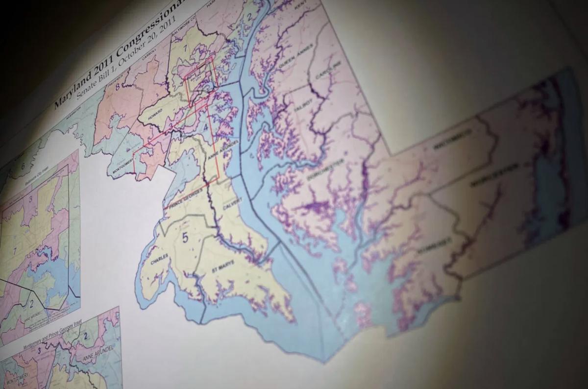
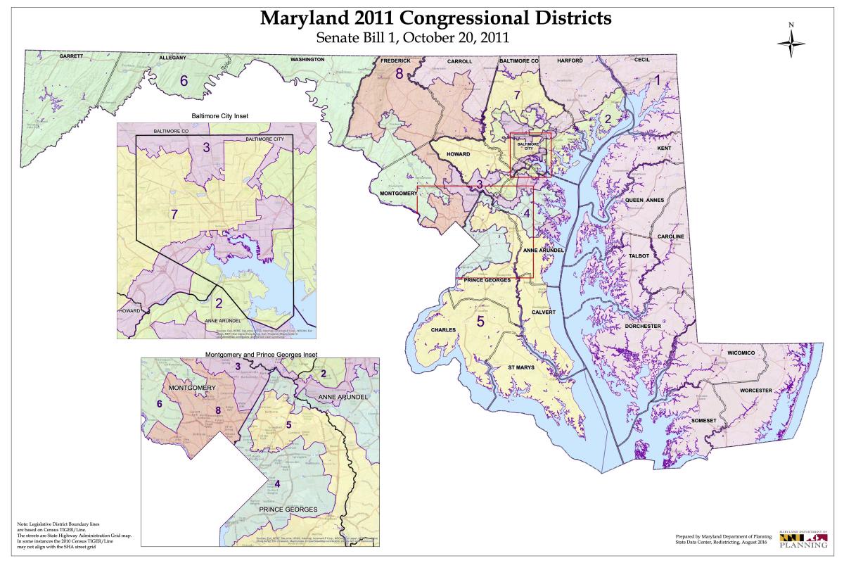
The biggest battles will occur with the congressional and state legislative district maps. Maryland’s current congressional map is considered one of the most gerrymandered in the nation. Gov. Martin O’Malley and Democratic lawmakers packed Democratic areas into a western Maryland district that had repeatedly elected a Republican to Congress. The mapping process following the 201o Census also put more Republicans into the First District, which encompasses the Eastern Shore.

As a result, Maryland’s congressional representation went from six Democrats and two Republicans to seven Democrats and one Republican (the First District’s Andy Harris).

Two redistricting commissions — one appointed by Gov. Larry Hogan and another by Maryland legislative leaders — are already at work on the maps for the congressional and legislative district maps.

The state planning department offers adjusted redistricting data on its website, which also includes a link to a mapping web portal through which anyone may submit proposed redistricting maps for review by the Maryland Citizens Redistricting Commission appointed by Hogan.

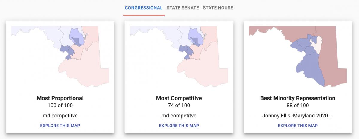
Outside groups also have offered maps, with several available to view at Dave’s Redistricting, “a free web app to create, view, analyze and share redistricting maps for all 50 states and the District of Columbia, according to the site.

The website offers five notable maps — most proportional, most competitive, best minority representation, most compact, and least splitting — for congressional, state senate, and state house redistricting plans.

At presstime, the notable congressional maps for proportionality, competitiveness, and compactness would split the Eastern Shore into two districts. The First Congressional District currently includes the entire Eastern Shore from Cecil to Worcester county and portions of Harford, Baltimore, and Carroll counties.

The current most proportional and most competitive congressional map would create a district that includes Queen Anne’s to Worcester county on the Eastern Shore, the southern Maryland counties of Calvert, Charles, and St. Mary’s, and a portion of Prince George’s County. That district is seen in yellow below.

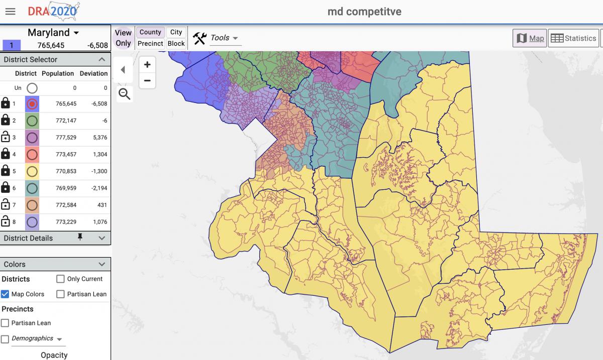
The most proportional and most competitive Maryland congressional district maps published thus far would include seven Eastern Shore counties, three southern Maryland counties, and a portion of Prince George’s County. Screenshot from Dave’s Redistricting.

The most compact congressional map has a district that includes Kent to Worcester county, the three southern Maryland counties, and portions of Prince George’s and Anne Arundel counties. That district is seen in light purple below.

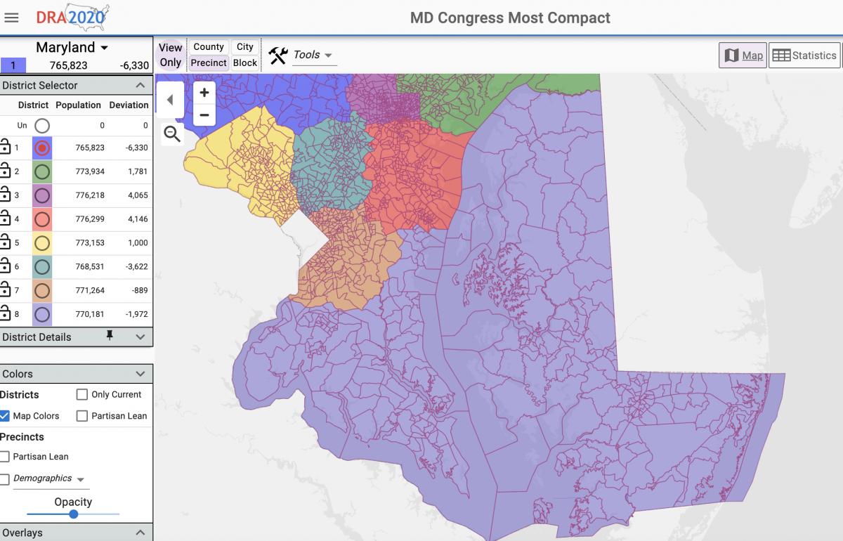
The most compact Maryland congressional district maps published thus far would include eight Eastern Shore counties, three southern Maryland counties, and portions of Prince George’s and Anne Arundel counties. Screenshot from Dave’s Redistricting.

The Spy Newspapers may periodically employ the assistance of artificial intelligence (AI) to enhance the clarity and accuracy of our content.

Filed Under: News Homepage Tagged With: census, congressional, county, districts, legislative, maps, Maryland, mid-shore, population, redistricting, school board

2020 Census Data: Fewer than Half of Marylanders are White, Baltimore Population Slips, Montgomery Surpasses 1M

August 13, 2021 by Maryland Matters

Maryland became more diverse over the last decade and the number of residents who identify as white alone dropped below half the state’s population, reflecting a nationwide trend, according to U.S. Census bureau data released Thursday afternoon.

The state’s overall population increased 7% since 2010, up to 6,177,224 residents in 2020. It is the first time the state’s population has topped more than 6 million residents in a decennial Census.

Montgomery County accounts for about one-sixth of the state population, and became the first jurisdiction in state history to register more than 1 million residents in the Census.

The data released Thursday also confirmed continued population loss in the city of Baltimore. In 1950, the city had just under a million residents — 949,708 — but that figure has been sliding ever since.

There were 585,708 Baltimoreans counted in the 2020 Census.

Here are four takeaways from the data:

Less than half of Marylanders identified as white

Less than half of Maryland’s population now identifies as white alone, according to Census data. The state saw a 10.5% decrease in the number of people who identify as white alone between 2010 and 2020, according to Census data, and that figure now stands at 48.7%.

Every county in the state saw decreases in the number of people identifying as white alone over the past decade.

The percentage of the population identifying as Hispanic or Latino increased from 8.2% in 2010 to 11.8% in 2020.

The percentage of Marylanders identifying as Asian alone increased from 5.5% in 2010 to 6.8% in 2020, and the percentage that identifies as Black or African American alone increased slightly from 29.4% in 2010 to 29.5% in 2020, according to the data.

Those figures reflect increasing diversity across the United States, according to Census data. The percentage of Americans identifying as white alone fell 8.6% nationwide between 2010 and 2020.

Garrett County had the largest white population in Maryland — 95.5% of county residents — while Prince George’s County had the smallest — 12.9%. The percentage of Prince George’s County residents who identify as white alone fell by nearly 25% over the last decade; the county ranks 11th nationwide for its percentage of non-white population, according to the Census Bureau.

Baltimore’s population dropped below 600,000 for the first time in a century

While Baltimore County grew between 2010 and 2020, the city of Baltimore saw yet another decline in population during the last decade.

The city had a population of 585,708 as of the 2020 Census compared with 620,961 in 2010, a 5.7% decrease. The 1910 Census was the last time Baltimore’s population was under 600,000. Baltimore’s population has been in decline since it topped out at 949,708 in 1950, according to the city’s planning department.

In a Thursday news release, Baltimore Mayor Brandon M. Scott (D) said he plans to launch a growth plan for 2030 aimed at improving quality of life in the city.

“Today’s population figures are the culmination of more than 70 years of population decline, showing why we must pivot from the status quo towards inclusive economic policies that improve the lives of our legacy residents, while attracting new residents,” Scott said in a release. “Understanding that much of Baltimore’s 21st century population loss has been driven by an exodus of African American households, my administration will be focused on equitable economic development. We can no longer leave any corner of our city behind.”

Baltimore’s 5.7% population percentage drop wasn’t the most dramatic in the state: Allegany County lost 9.3% of its population between 2010 and 2020, dropping from 75,087 to 68,106.

Somerset County saw a 7% decrease, with its population decreasing from 26,470 to 24,620.

Kent County, Maryland’s smallest by population, saw a 4.9% decrease, dipping below 20,000 to 19,198.

Dorchester, Garrett and Talbot counties also saw population decreases.

Montgomery County tops 1 million residents; Frederick, Howard and Charles saw massive growth

Montgomery County became the first Maryland jurisdiction in history with a population topping 1 million in a decennial census. The county’s official population grew 9.3% in the last decade and now stands at 1,062,061.

Montgomery’s population has more than doubled since the 1970 Census, when there were 522,809 residents.

Frederick County was home to the fastest growth in Maryland, with its population increasing by 16.4% between 2010 and 2020.

Howard County saw a 15.8% increase in its population, and Charles County saw a 13.7% increase.

In all, seven of Maryland’s “Big Eight” counties saw population growth over the past decade.

Prince George’s County’s population grew by 12%; Anne Arundel County saw a 9.4% increase and now has a higher population than Baltimore City at 588,261; Harford County saw a 6.6% increase; and Baltimore County’s population increased by 6.1%.

Southern Maryland’s growth wasn’t confined to Charles County: St. Mary’s County saw a population increase of 8.2% and Calvert County’s population increased by 4.6%.

What does this data mean for redistricting?

The raw, untabulated data released by Census officials Thursday will be used by lawmakers and redistricting commissions across the country for mapmaking — but it will need some adjustments before it’s ready to be used in Maryland’s redistricting process.

Maryland Department of Planning officials will need several weeks to adjust the data to comply with Maryland law and move currently incarcerated people back to their last known address. Once that adjustment is finished, that data will be used by Maryland’s dueling redistricting commissions to draw up proposed congressional and legislative maps.

By Bennett Leckrone, Danielle E. Gaines, and William F. Zorzi.

The Spy Newspapers may periodically employ the assistance of artificial intelligence (AI) to enhance the clarity and accuracy of our content.

Filed Under: Maryland News Tagged With: census, Maryland, population, redistricting

Census Data Delay Likely Means No Redistricting Session This Fall in Md.

February 18, 2021 by Maryland Matters

The U.S. Census Bureau’s decision to delay releasing population data until fall almost certainly guarantees that Maryland lawmakers won’t redraw the state’s political boundaries before next year, political analysts said on Tuesday.

The bureau originally planned to get results of the 2020 Census to states by March 31. But officials announced on Friday that they will provide it by Sept. 30 instead.

They blamed the delay on the COVID-19 crisis, which made surveying every household in the country, a labor-intensive process that involves millions of face-to-face interactions, more difficult.

Maryland and other states will use the data — once they get it — to craft congressional and legislative boundaries that will be used for the next five election cycles, beginning with U.S. House and General Assembly contests in 2022.

The delay in receiving population data makes it highly unlikely the legislature will meet in special session this fall, according to three people knowledgeable about the process.

Instead, lawmakers will have to tackle congressional and legislative redistricting when they convene in January for the 2021 session.

There is no way to replicate the more generous timeline that lawmakers had in 2011, said Patrick H. Murray, a former chief of staff for the late Senate President Thomas V. Mike Miller Jr., now the top aide to Baltimore County Executive John A. Olszewski Jr. (D).

For that redistricting, then Gov. Martin J. O’Malley (D) announced a redistricting committee in the summer, the committee drafted a congressional map in early October and the legislature convened a special session to consider it later that month, Murray recalled.

Given advances in computer software since the 2011 redistricting, lawmakers and their staffs won’t necessarily need a lot of time to draw new lines, said Daniel M. Clements, a retired lawyer and longtime Democratic activist who has been involved in past redistricting efforts.

But pitched battles that often occur internally — among incumbent members of Congress and the General Assembly over various precincts — can take time to resolve.

The 2022 primary election is set for June 28. And the deadline for candidates to file is Feb. 22.

Assuming it does not get pushed back, legislators will have less than six weeks to conclude a process that is fraught with political intrigue and where emotions can run hot.

“You will have that piece, but the shorter time means they just have to resolve it quicker,” Clements said.

In January, Gov. Lawrence J. Hogan Jr. (R) created a nine-person redistricting commission to study Maryland’s population changes, take public input and draw a set of boundaries that he can submit to the legislature.

The panel will have three Democrats, three Republicans and three voters who aren’t registered with any political party.

Cato Institute senior fellow Walter Olson, a Republican; retired federal judge Alex Williams, a Democrat; and Howard Community College President Kathleen Hetherington, an independent, will serve as co-chairs.

The other six slots will be filled by a group of applicants who put their names forward prior to the Feb. 12 deadline.

Olson would not disclose the number of people that applied, but he described them as “an impressive and diverse group of applicants.”

The governor’s commission will hold statewide hearings once it is empaneled.

Olson said the delay in Census data compresses the amount of time the panel will have to do their work.

“Our work has to be done later and with somewhat more time pressure than would have been predicted,” he said. “We have our assignment, which is to propose maps for U.S. House [districts] and for the General Assembly. Whether a special session occurs or not is not part of our to-do list.”

Speaking on WBAL Radio, Hogan again slammed Democratic leaders in the General Assembly for how they have drawn lines in the past and for rebuffing his efforts to take line-drawing out of the hands of legislators.

He pledged to submit the commission’s maps as his own, “without any influence or tampering.”

“I have the power as governor to draw districts,” he added. After that, he conceded, “it’s a battle between the executive branch and the legislative branch.”

By Bruce DePuyt

The Spy Newspapers may periodically employ the assistance of artificial intelligence (AI) to enhance the clarity and accuracy of our content.

Filed Under: Maryland News Tagged With: census, Congress, general assembly, Maryland, population, redistricting

Md. Lawmakers Will Map Congressional Districts Based on 2020 Census

January 12, 2021 by Spy Desk

Maryland lawmakers later this year will draw new maps for the state’s congressional districts based on the latest population statistics from the 2020 Census.

The U.S. Constitution requires the census to be conducted every 10 years. The population numbers are then used by states to draw new congressional districts, which typically is completed in time for the congressional election two years after the census.

Following the decennial census, federal law requires states to be notified by Jan. 25 by the clerk of the U.S. House of Representatives on the number of congressional seats that state will have for the next 10 years.

That notification will be delayed this year, however, as the U.S. Census Bureau continues processing and tabulating the population numbers.

According to The Washington Post, the census bureau currently believes it will finalize state population numbers by March 6, more than two months after the Dec. 31 deadline.

The deadline was missed as a result of delays caused by the coronavirus pandemic and changes made by the administration of President Donald Trump, which is being sued over some of its decisions concerning the census.

Although the count continues, population estimates suggest Maryland will retain its eight seats in the U.S. House of Representatives.

Once the state is told how many seats it will have, Maryland lawmakers will draw new boundaries for those congressional districts. After the congressional map is approved by the Maryland General Assembly, it is subject to veto by Gov. Larry Hogan.


The Spy Newspapers may periodically employ the assistance of artificial intelligence (AI) to enhance the clarity and accuracy of our content.

Filed Under: Maryland News Tagged With: apportionment, census, Congress, districts, population, redistricting

Copyright © 2023

Affiliated News

  • The Chestertown Spy
  • The Talbot Spy

Sections

  • Arts
  • Culture
  • Ecosystem
  • Education
  • Mid-Shore Health
  • Culture and Local Life
  • Shore Recovery
  • Spy Senior Nation

Spy Community Media

  • Subscribe
  • Contact Us
  • Advertising & Underwriting

Copyright © 2023 · Spy Community Media Child Theme on Genesis Framework · WordPress · Log in